So, this is the first installment of AT Day Hikes, and I am
starting in North Carolina with my hike to Rich Mountain Fire Tower. There are
a number of reasons why I am starting with this one. It is winter time and this
was a wintery hike, and it is recent so these are a couple of reasons I guess that make it more relative.
Also, when I was reading Doris Gove’s book
Exploring the Appalachian Trail, Hikes in the Southern Appalachians she
said that “Midsummer hiking here can be hot, but spring and fall are pleasant,
and main-road access would make this a good winter choice.” This is one of the
main reasons my friend Glen Yelton and I decided to head out on this hike on the last
day of November.
The access trailhead for this part of the
Appalachian Trail (AT) is
Tanyard Gap,
which is 3 miles north (or by AT miles 5.3) of
Hot Springs off US 25/70. On
Wednesday, three days before our hike
Greeneville had been blanked with snow, and it was still there Thanksgiving morning. However, by Friday it was all but gone.
So, when we left out Saturday morning I don’t think we really expect to see
snow, but as we got toward Allen Gap we could still see white powder on
Camp Creek Bald. Once we crossed over into North Carolina it was noticeable colder and a
little snowier. It was funny we saw a guy fly fishing in a stream and he was
still there fishing when we came back hours later…hardcore!
Anyway, getting to the parking area you turn right off of US
25/70 and then a quick left onto Lookout Mountain road. The parking area is where
the road turns left across the one lane hiker bridge (which the AT crosses).
 |
| A lone hiker follows the AT across the bridge over US 25/70. |
According
to the
Appalachian Trail Parking site there is parking for 5-to-6 cars. On the
asphalt there is a double blaze which indicates a trail junction, I guess with the road.
The
southbound trails cross the bridge while the northbound part that we wanted headed
down an old roadbed to a set of stairs. About another 0.1 miles there is another
set of log stairs, these even have a rail. At this point there was some snow, but it was patchy and it
was cold, but not too bad. One of the reasons that this makes a good day hike is I
would consider the trail moderate in difficulty. Don’t get me wrong this is a
backcountry trail, so it always will have a level of difficulty greater than
say
Sawnee Mountain, but as compared to other spots on the AT I have hiked it
is moderate.
 |
| Second set of stairs just up the trail. |
Well, there are two things I sometimes like to look for on the trail.
One is water, the second places to camp. When it comes to water you never know
when you will need some and it is good to know where access to water is. At one-mile in you cross a second log footbridge and here is a small water source. To
get to an even better water source you first cross a flat area, at 1.3 mile
mark, which sports a nice camping spot, with a fire ring. What makes it even
better is that tenth-of-a-mile up the trail is an excellent spring with good
water. It even has a plastic spout.
 |
| Log footbridge with small stream. |
 |
| Camping site just off AT. |
 |
| The spout for the spring is on the left and part of the log footbridge is to the right. |
The next spot I have to mention refers to something that is
described in the
AT Trail Guide for Tennessee-North Carolina. At about the two-mile mark of the hike the Guide says that the trail is on an old road for 50
feet. In actuality the trail skirts the road and hooks away from it. Around
this spot is where the snow became real noticeable. For about this point on it
was snow covered.
 |
| The old service road can be seen in the distance |
After a tenth-of-a-mile uphill through mountain laurel and
rhododendron we ran into the familiar double blaze indicating the junction for
the
Roundtop Ridge Trail. This yellow blazed trail is the old AT route to
Hot Springs. It is still maintained by the USFS with the trail number designation
295 (for those using the AT Tennessee-North Carolina Maps 3 & 4 or National
Geographic map #782).
Our finally junction was still half-mile ahead, and by this
point the difference to the lower part of the trail was striking. There
was at least 3+ inches of snow on the ground and it was noticeable colder. So,
we were almost there at the trailhead to the
Rich Mountain Fire Tower, which went left and
the AT continued right towards Hurricane Gap and then Allen Gap. If
one has two cars an 8.9 mile day hike can be made from
Tanyard Gap to Allen
Gap. We met two hikers a man and women who came from Allen Gap and were hiking
to
Hot Springs. They said the snow was even deeper on the stretch from
Hurricane to Allen Gaps.
 |
| Snowy AT. |
 |
| Me in the snow on the AT. |
 |
| AT heads downhill toward Hurricane Gap. |
 |
| Junction for the Rich Mountain Fire Tower Spur. |
So, we went left because our final destination lay 0.1 miles
up the Rich Mountain spur. I will say it is always nice when going to a fire
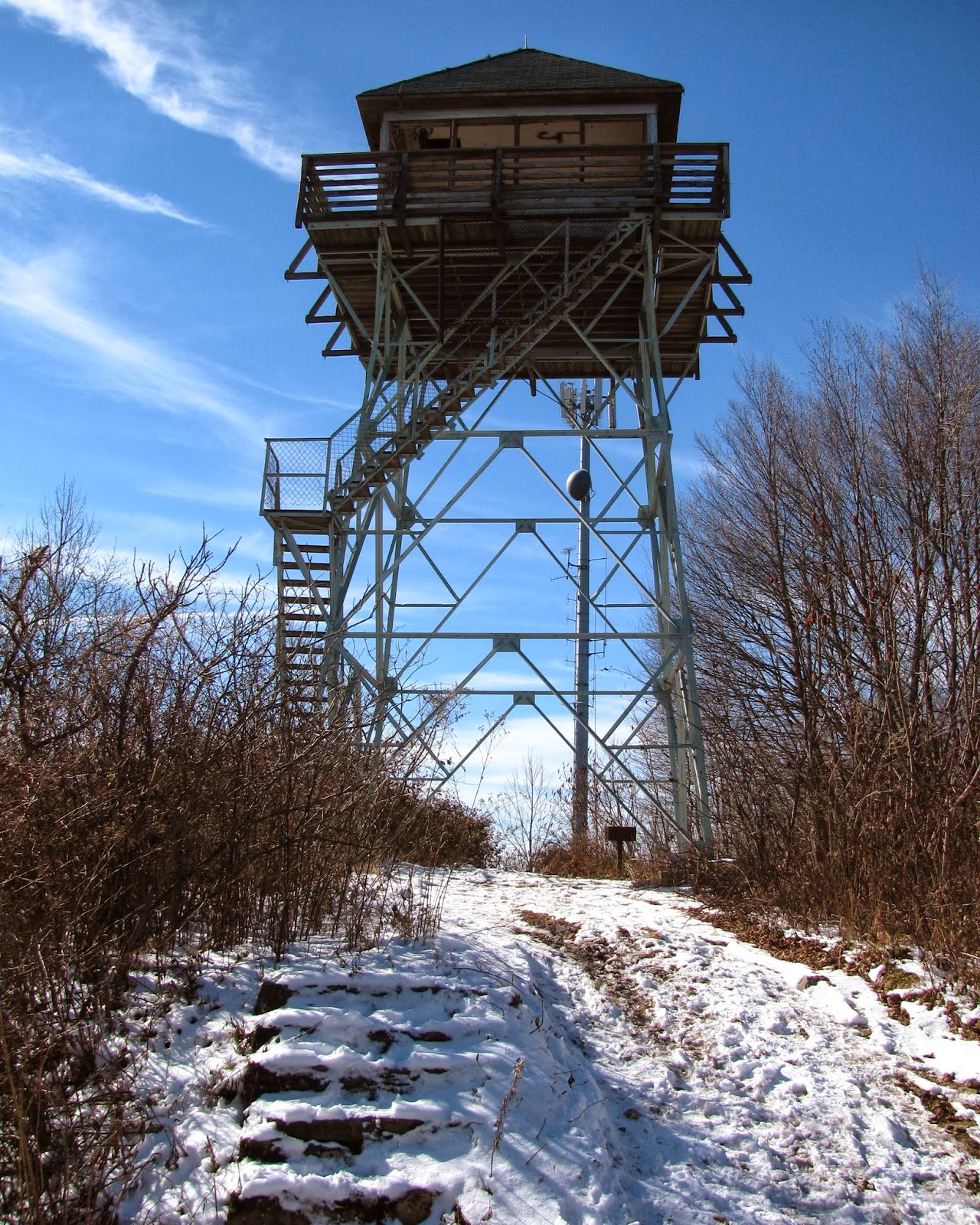
tower is the first time you see it. Actually one first spots the fire tower on
Rich Mountain from about a mile down the trail. However, glimpsing it for the first time when
nearing it tells you that the destination is hand.
 |
| First look at fire tower & communication tower. |
As we approached, there was an
ATV parked near the tower (not just a four wheeler, but the really nice ones
with seats). The first thing that crossed my mind was hunters, since it was
the Thanksgiving holiday and that means deer hunting is in full swing. If you notice
from any pictures of me this time of the year I am wearing orange on the trail because I don't want to get shot!
One might ask how an ATV got to the fire tower. Well the AT
is not the only way to the mountain top. Hurricane Gap Road (FS 31) starts at
Paint Creek Recreation Area and winds up Rich Mountain where it crosses Hurricane Gap until it
ends at the fire tower. The owners of the ATV were a family of four, a Dad, Mom, their
young son and teenaged daughter who were from Greeneville (just like us).
Speaking of Tennessee, like a lot of the AT
in this area the fire tower straddled the state line between North Carolina and
Tennessee.
Some fire towers have limited access like the one at
Camp Creek Bald (8 miles away or 15.1 in AT miles) or no access like the
Black Mountain Fire Tower near
Woody Gap in North Georgia. But one of the reasons I
wanted to make this hike was because this tower had full access.
 |
| Glen & I at the steps of the fire tower. |
 |
| Inside the fire tower. |
Rich Mountain Fire Tower was built in 1932 by USFS. The 30-foot high tower had a live-in cabin.
While it creased as a live-in lookout in the 1970’s it was fully staffed until
the 1990’s. Inside the tower is now empty, except for the graffiti on the walls
and ceiling. It used to house communication aerials, but they have since been
moved to a single tower allowing for the tower to be opened for viewing.
Let me say…what a view! The pictures I post here can give
you an idea on how wonderful the view is, but they can’t really do it justice. To
the northeast
Big Bald, Flatrock Mountain and the before mentioned
Camp Creek Bald and fire tower can clearly be seen. Facing east
Roan Mountain is in the distance. Southeast of the tower is the Black
Mountains, including
Mount Mitchell. South is the Great Balsam Mountains. Southwest from the tower is the
Smoky Mountains, Snowbird Mountain and
Max Patch. Finally to the west is Knoxville and northwest is
Greeneville.
 |
| Northeast: Flatrock Mtn, Unaka Mtn, No Business Knob & Big Bald. |
 |
| South: Great Balsam Mountains. |
 |
| West: Knoxville is out in the distance. |
I have been at the top of a number of mountains with fantastic
vistas, but there are not too many that are any better than here. Even though it was COLD
on the tower the view was more than worth it. Well at some point you have to
start the journey back, so it is down the steep stairs and past an old barbeque
grill (I take it there used to be a picnic table up here, but I think it is
gone now). It was amazing how within a half-mile from the Rich Mountain/AT
junction that the temperature difference was at least 10 degrees.
 |
| On the way back a lot of the snow had melted. |
 |
| 4WD needed on Mill Ridge Rd. |
The hike back was just as delightful as the trip up. It was mostly down hill so that might have been some of the reason. We ran into a number of hikers on the way back, it is always fun to interact and trade stories with others on the trail. When we got back to the parking area a family in a passenger car asked about going up the road over the bridge. I guess they wanted to go toward the Mill Ridge area, but the way the road looked I advised them against it.
I will say that at the end of the day with the snow and hiking
with a good friend this was one of my favorite day hikes. Oh, and I would recommend this
hike to anyone at anytime of the year. Directions to Tanyard Gap: From Greeneville, TN (27.4 miles) take TN 70 S (Asheville Highway) turns into NC 208 S at 24 miles turn right onto US 25/70. Go two miles to Lookout Mountain Road.
Bonus: There were some cool stuff on the way back from Tanyard Gap, so here area some photos.
 |
| Turkeys...we spotted them not too far from Tanyard Gap. |
 |
| Man made waterfall...the old Nolichucky Substation. |
 |
| The old substation building. |
More photos of this hike on my
Facebook page.


No comments:
Post a Comment