In Georgia, of all the Appalachian Trail (AT) Section in the Peach State, the one I wanted to do more than any was NC-GA Section #15, Woody Gap to Neel Gap (original blog). The section features some of the most popular spots on the AT in Georgia like Preaching Rock and Blood Mountain. Since the only direction, I have hiked this whole section in is Northbound that means this blog will start at another popular spot on the AT...Woody Gap. In a lot of ways, this is Georgia's Carvers Gap. Located where GA-60 passes between Black and Big Cedar Mountains above Suches.
It is popular because it has ample parking on both sides of the road. But on a nice day, these spots fill up fast. Here you will find a vault toilet there are cool signs, two information kiosks, a nice view, and the Woody Gap Rock.
As you enter the Blood Mountain Wilderness, the first part of the hike, as I had seen described, is a leisurely stroll through hardwoods on a relatively nice part of the AT. After heading north for a half-mile and passing Lunsford Gap one comes to the spot when the trail starts to switchback up the mountain.
 |
| Lunsford Gap |
Like most of North Georgia, it is rocky but well maintained by the Georgia Appalachian Trail Club (GATC). About halfway up (past the Evil Dead Tree) one gets their first look at the vistas of Big Cedar Mountain. To get a good look one must climb up a steep rock face. I would say at this spot it is best to be careful because one could easily lose their footing. Also, something else to be careful of in spots during warmer months is snakes. Two kinds of poisonous snakes are found in the North Georgia Mountains Copperheads and Timber Rattlesnakes. I know when I was up there in October 2014 someone spied one sunning on a rock on the trail up Big Cedar Mountain. Just up the trail from the first outcrop is a second which is a little more accessible, it also gives a nice view of the valley below. But this one is better in Winter and early Spring.
 |
| Vista #1 |
 |
| Vista #2 |
The AT winds up through boulders and final crests, at one-mile, to a gorgeous open large rock face which signals one's arrival at Preaching Rock. This is truly a spectacular view. The southeast vista gives a stunning look of the North Georgia Mountains. Adding to the great vista is there is plenty of room on the rock face for large groups of people, which on weekends is a good thing. Unlike Tray Mountain which surprised me by how small its summit is this one is as advertised.
 |
| Preaching Rock |
Back on the trail, there is first a short climb up toward the summit area of Big Cedar Mountain. After cresting there is a slight downhill and one will come to a junction with the AT going left and the blue blaze right goes to what I call the Big Cedar Overlook. It is a large outcrop, but not quite as big as Preaching Rock but is nice and unobstructed. Obvious people camp here because the place sports a fire ring on the outcrop. Since my first trip there I have heard about a third spot, but on visiting it is now mostly grown-up, similar to the condition I found a similar spot at Levelland Mountain. In some ways, it is better than Preaching Rocks because it is not crowded and makes a good spot for a break.


 |
| Junction to Big Cedar Mountain Vista |
 |
| Big Cedar Mountain Vista |
Once back on the AT it isn't long before coming to another spot which is about another third-of-a-mile up the AT from the Big Cedar Overlook and that is what people call the “Captain Morgan” tree. From the h-Tree to Jarrard Gap is close to four and a half miles. The trail moves down into Au
rgerhole Gap passing a large rock. It is then downhill passing a small waterfall Dan Gap. The gap before the AT heads back up to
Granny Top. At 3,505 it is just over a 300-foot climb up, but it is steeper than either of the topographical views of the mountains one finds in
Dave “AWOL” Miller’s guide or the
official one. It might be that it doesn’t switch back much here.
 |
| The Captain Morgan Tree |
Once on Granny Top it the trail heads back down into Miller Gap at 2.9 miles. It is here that one finds the junction with the Dockery Lake Trail. This blue-blazed trail goes 3.5 miles down to
Dockery Lake Recreation Area. The trail which has a hidden 200-foot waterfall at Pigeon Roast Creek leads to a lake with camping, bathrooms and day-use parking.
 |
| Dockery Lake Junction |
From here the AT continues down until you reach Lance Creek. This is a popular camping area because it is the last spot with good water before the
bear canister regulation kicks in at Jarrard Gap. For those who don’t know from March 1 to June 1, all hikers camping between Jarrard Gap and Neel Gap (and this includes Blood Mountain) must use a bear canister. Since most thru-hikers don’t want to carry one they camp here. However, since it has become so popular there have been consequences. The U.S. Forest Service (USFS) and the GATC have worked on stream restoration in the area. That is why you will find a sign and ropes just before the small footbridge (this might have changed since I passed through in 2015).
The trail goes uphill for a bit before leveling out at Henry Gap where it skirts a ridge before turning. It then climbs up to a flat summit area called
Burnett Field Mountain (3,478 feet) at 5.1 miles. This is a beautiful area that leads finally leads down half-mile to Jarrard Gap.
On arriving at Jarrard Gap you will notice an old road crossing with the blue blaze part to the left heading down one-mile to
Lake Winfield Scott Recreation Area. Known as the Jarrard Gap Trail it is part of the Slaughter Creek Loop Hike I did. Anyway, mileage-wise Jarrard Gap is slightly over half it is the unofficial midway point of the hike and makes for a good lunch spot. I should mention in Spring you will find an abundance of wildflowers in this area.
From here to Bird Gap it is about 1.6 miles of what I consider a moderate trail. There are some up and down spots as the trail passes Gaddis and Turkey Stamp Mountains. I will say this is a nice stretch of trail with some beautiful trees. When one reaches Bird Gap the first trail junction you pass is the blue-blazed path to the Woods Hole Shelter. It is a half-mile one way to it and it is because of that distance that I have never been to this shelter.
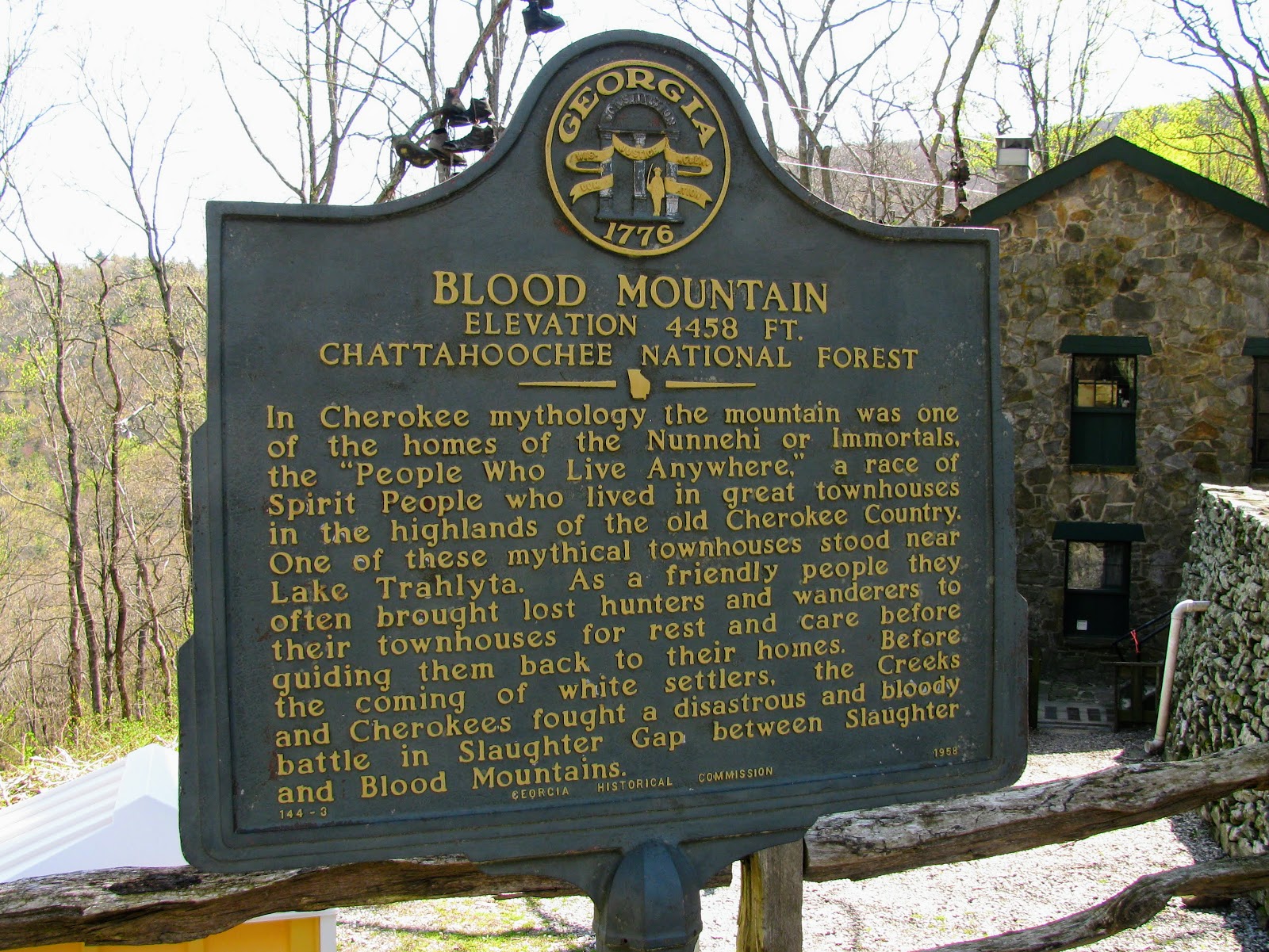
There is also a trail intersection a little over a mile from Bird Gap at Slaughter Gap. The gap gets its name from nearby Slaughter Mountain and both from the same battle that gave Blood its moniker (see sign for story). This spot has been a little confusing in some books and maps, but most current information lines up.
So, the first trail junction you come to is the Slaughter Creek Trail which goes 2.7 miles to Lake Winfield Scott and makes up part of the Slaughter Creek Loop. The trail goes up stone steps going right as it is turning left the is a sign for campsites. For thru-hikers or any other campers, this spot has sites for eight tents. There is water at Slaughter Creek, but there is a campfire ban from the Slaughter Creek Trail sign to Neel Gap. Then just up the trail is the junction to the Duncan Ridge Trail which is a 35-mile trail and this is its Northern Ternmuis. If you remember Long Creek Falls is at its southern one.
From this point it is about a half-mile to the summit of Blood Mountain it is at this point that one will encounter the only steep part on this section of the trail as you scale the summit. It does switchback up through rhododendrons which helps.
Finally, at 8.2 miles the AT brings you to the amazing summit of Blood Mountain,. Unlike, some summits where there might be a small vista, at Blood you’re taken back by how large the area is. However, the heart of the summit is the old shelter. When one comes up the northbound AT you will pass the privy and then you see the iconic shelter and that is when you know you have made it. The old shelter is one of the most iconic on the entire AT. The two-room stone building was constructed by the CCC (I sometimes wonder if anything would have ever have been built without the CCC) in 1934. It would be refurbished by the GATC in 1981 Places again in 2012. In January of 2013, it was listed on the and the National Register of Historic. It has two rooms the front one has a stone floor and the second has one of cement. It is a welcome respite for hikers to spend the night or to get out of a thunderstorm. But, be warned you may have to share the space because the shelter is rumored to have a healthy mice population.

 |
| The CCC Shelter |
Since we are on the subject of shelter, there are several places to camp on the summit. Now remember there is no water source and there is that pesky campfire band, but if you look around one will see plenty of fire rings including one outside of the Blood Mountain Shelter. However, there is a reason for the campfire ban you could say that the mountain is a victim of its beauty. As I said earlier, this is the most visited spot on the AT in Georgia and it is the most visited place on the trail south of Clingmans Dome. So, the U.S. Forest Service (USFS) put in the ban to allow overused areas a chance to return to its natural state. Remember when on the summit the Leave No Trace policy is the best policy and honor the no campfire ban.


Anyway, while the shelter is one of the cool things you will find near the summit, the view is the real star in the shelter area. To the west one can look and see Vogel State Park and further out in the distance one gets a clear view of Georgia’s highest peak, Brasstown Bald.
While the west side vista is just over from the shelter (which can be seen from Vogel Knob at the nearby state park), one has to climb to get to the south-facing view known as Picnic Rock. You have to climb up, but once you are there it was more than worth the effort. The mountains any thru-hiker must traverse are visible to the southwest including Big Cedar Mountain. It is just one of many places on Blood Mountain that one can sit and soak in the view. From here you are about level with the roof of the shelter. I guess I should add that it is a sloping cliff face, so if it was wet or icy it could be dangerous.
 |
| Brasstown Bald |
 |
| Black & Big Cedar Mountain |
 |
| Picnic Rock |
 |
| Tray Mountain |
 |
| Yonah Mountain |
After the longest two-tenths of a mile, the AT starts this steep, rocky climb down from Blood Mountain. It switchbacks, which helps and thanks to the GATC the blazes keep you on the path which once wasn't the case. On the way down you will first pass Pyramid Rock and then another I call Big AT Rock (because it has a white-blaze on it). You will notice that the trail is well worn and if it has rained it will be fairly sloppy because it is well-traveled. But, you will probably know that from the streams of people heading South on the AT. After a mile, you will know you have reached Flatrock Gap because this is the junction they will be using as they will be coming up (seven-tenths mile trail) from the Byron Reese Memorial, which is the day-hiker parking.
 |
| Pyramid Rock |
 |
| Big AT Rock |
 |
| Flatrock Gap |
The final part of this hike was one-mile from Flatrock Gap to Neel Gap. The main highlight of the hike to Neel Gap is just little more than a tenth of a mile down as you come to Balance Rock. This formation of boulders looks like one balanced on another it is pretty cool. Right down from it is a huge boulder that looks like a giant whale or turtle, it is your choice. The AT here will wind through Rhododendrons before heading down toward Neel Gap. You know your close because you can hear the traffic on US 19, in winter you can see the road. Finally, you are there, the first thing you see is the Blood Mountain Wilderness sign and information board. Then there is the section hike Neel Gap sign with the mileage to Woody Gap, which I called the finish line. Oh, there is also the second George Noble plaque and Mountain Crossing across the road. This is where I finished AT Section #14 Blog.
 |
| Balance Rock |