For my fifth Appalachian Trail Section, I go to my favorite trail town Hot Springs over Rich Mountain to Allen Gap. Like my previous AT Section
blog, this one will end at Allen Gap for the same reason I have only done the whole thing South to North. Like NC-TN Section #13 I did it in a couple of segments. So let's go to where this section starts Hot Springs, NC.
The first part of this hike is actually on the sidewalk as the AT cuts through the middle of Hot Springs. On the sidewalks are AT logos in the concrete, which is really cool. There is also the Earl Schaffer plaque at the Welcome Center. For those who don't know Hot Springs is a mountain oasis of just 560 people that is famous for its..., you guessed its, hot springs (specifically the Hot Springs Resort & Spa). It has a great outdoor store in
Bluff Mountain Outfitters and a good place to have a beer at
Spring Creek Tavern. As AT trail towns go it might be my favorite.
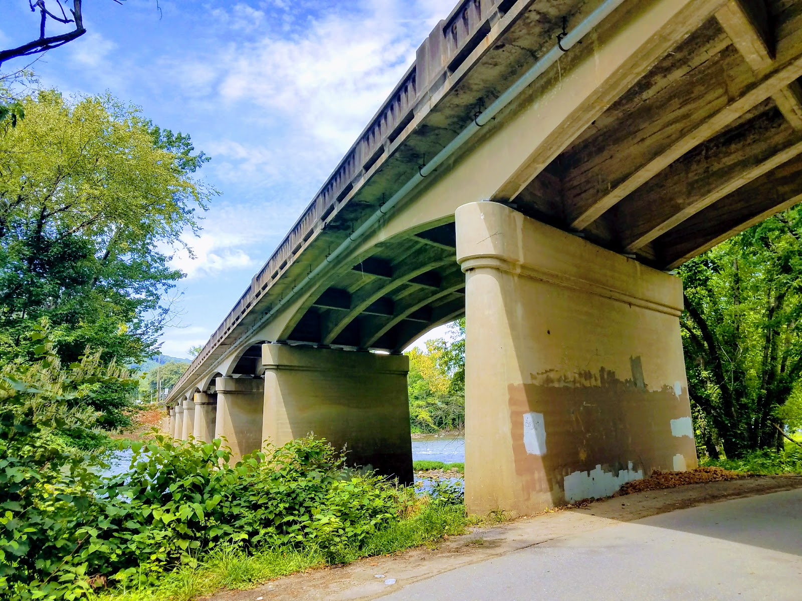
Once the trail heads out of town it crosses the bridge over the French Broad River before heading off the road at the far end of the bridge. The AT follows some steps down to another road that it follows for a short time cutting through the
French Broad Outpost of the
Nathalala Outdoor Center. It crosses a bridge and becomes a trail again as the AT parallels the French Broad River for the next half-mile.
Besides the river itself, one of the highlights is passing by Lovers Leap Rock (which I will talk about climbing down to) The other is what I call the French Broad Cascades. While the only couple of feet high it stretches almost all the way across the river....cool. Finally, the AT turns left and heads up. While a nice climb it isn't the steepest and the AT is pretty wide through here.
At about two-tenths-of-a-mile on the climb up, you reach the first vista and no this isn't Lovers Leap. That will come in about another two-tenths. When you get there you will see a trail that leads steeply down to a narrow outcrop that looks a lot like a mini
Charles Bunion, that might be because both are quartzite formations. There is no question it provides the best vista, but it is not for the faint of heart. As the trail goes up it will switchback the trail turn and here to the right is another nice view.
Finally, the AT reaches a junction with the Lovers Leap Trail as it goes left and the AT straight. There is a decent view of Hot Springs from here, but remember this isn't the Lovers Leap. The AT climbs Lovers Leap Ridge, but there is another nice view along the way. To get to it there is a junction with the AT going left and right leads to what I call "the Narrow." The reason it is a knife-edge outcrop which offers a vista of the French Broad River and Hot Springs.
Once back on the AT the path leads up to a sideline before turning down toward Pump Gap. On the way, there is a view of Rich Mountain and the old fire tower, which is easier to view in winter. You will know you have reached Pump Gap because the is a sign which acknowledges the work of
Boy Scout Troop #374, out of Raleigh, where they treated
Hemlock Trees infested with the
Woolly Adelgid. Also, the yellow-blazed Pump Gap Trail crosses here.
Since it is a gap the trail climbs out of it, but the feature one will notice is the fire damage from the blaze in April of 2016. It is about two miles when you finally reach Mill Ridge Pond. This is a nice place to take a break and in August you will find Cardinal Flowers on its banks.
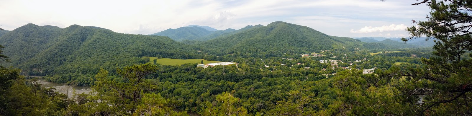
The trail heads up and intersects with Mill Ridge Road. If you go right off the AT on the road it is a short distance to a turnaround. Once here there is an overlook with a really nice view. Well back on the AT, which heads left, up to the open fields of Mill Ridge. This is a beautiful spot with a good view of the Rich Mountain. Also, on my first visit here in August 2016, the field was full of beautiful sunflowers. The road forks at a huge Oak Tree to the right is the parking area for Mill Ridge Bike Trail while the AT follows the road.
87+
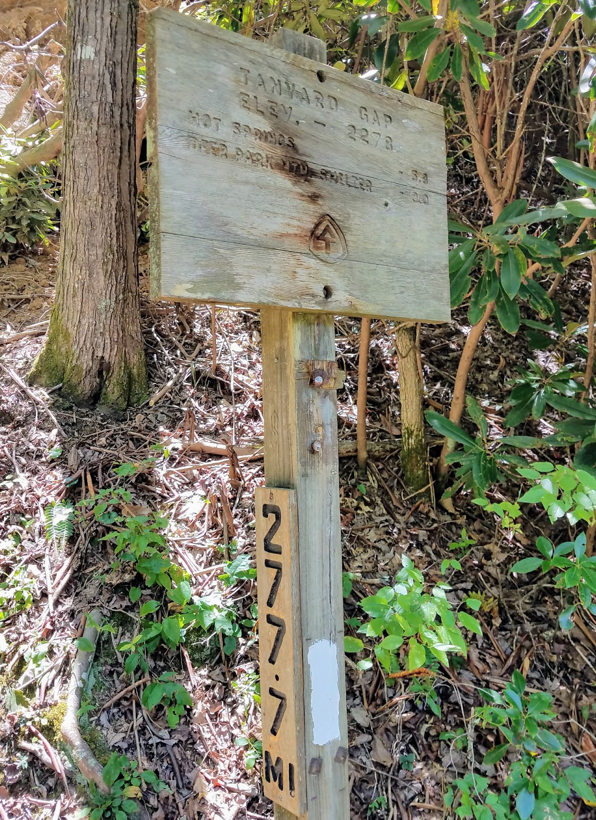
As the road heads down it curves left as the AT heads back in the woods. The last half-mile the AT travels above Mill Ridge Road heading through some rhododendron tunnels before heading to the steps that lead back down to the road and the bridge crossing at Tanyard Gap. this gap makes a good place for a day hike which I have done hear many times.


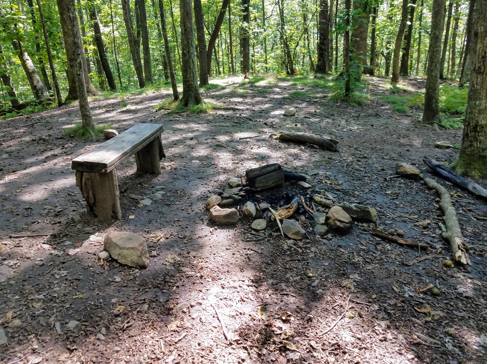
Once across the bridge, the trail starts up, the stairs to the right into the woods. About another 0.1 miles, there is another set of log stairs. One of the reasons that this makes a good day hike is I would consider the trail moderate in difficulty. The AT skirts a road as it turns left before entering an area still recovering from fire damage that closed this part of AT in 2016. At one-mile in you cross a second log footbridge and here is a small water source. To get to an even better water source you first cross a flat area, at 1.3-mile mark, which sports a nice camping spot, with a fire ring. What makes it even better is that tenth-of-a-mile up the trail is an excellent piped spring.


The next spot I have to mention refers to something that is described in the
AT Trail Guide for Tennessee-North Carolina. At about the two-mile mark of the hike, the Guide says that the trail is on an old road for 50 feet. In actuality, the trail skirts the road and hooks away from it. After a tenth-of-a-mile uphill through mountain laurel and rhododendron, we ran into the familiar double blaze indicating the junction for the
Roundtop Ridge Trail. This yellow-blazed trail is the old AT route to
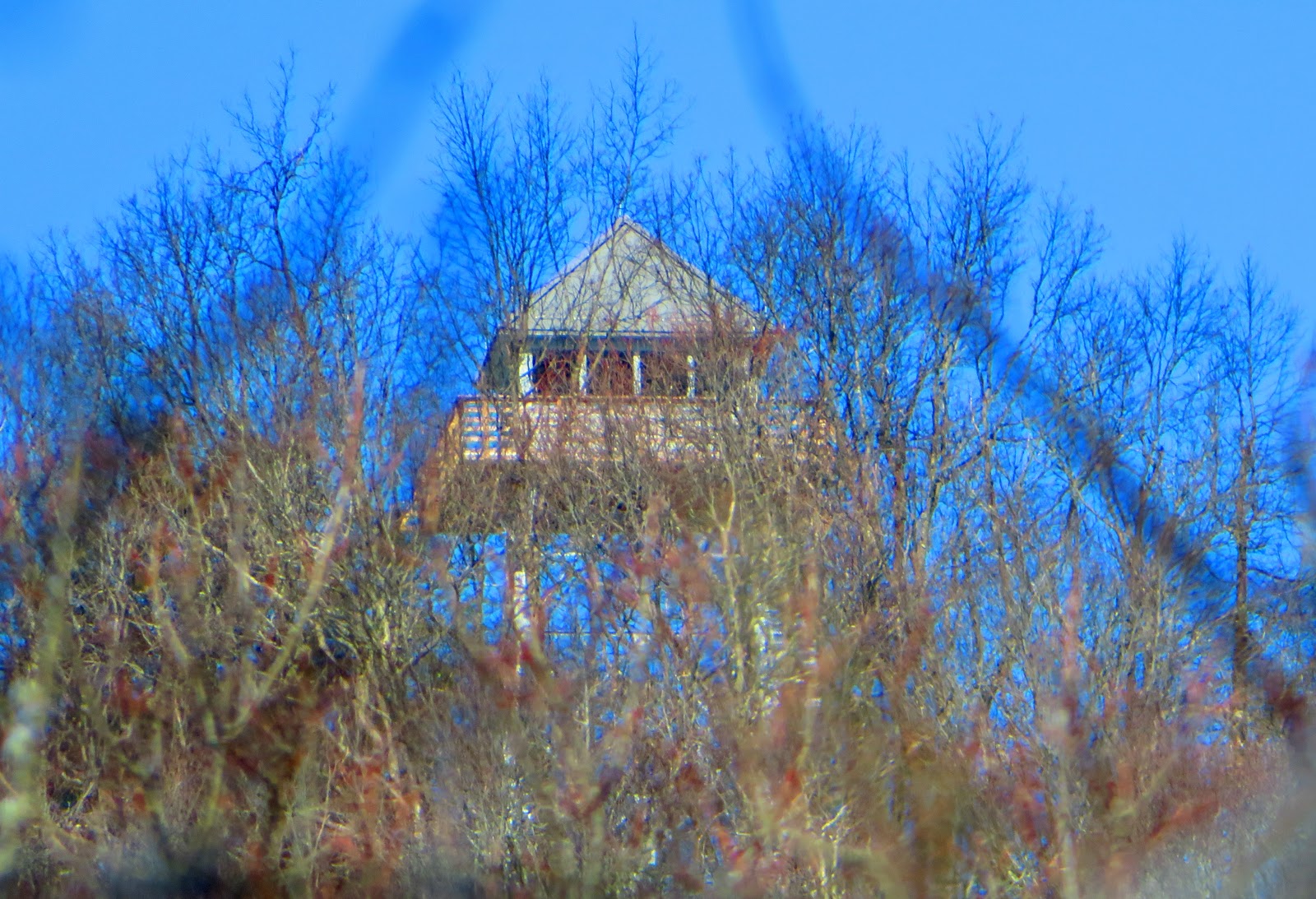
Hot Springs. It is still maintained by the USFS with the trail number designation 295 (for those using the AT Tennessee-North Carolina Maps 3 & 4 or National Geographic map #782). Oh, it marks half-way of this section. The AT follows the right-side of Rich Mountain before heading up and arriving at the junction for the fire tower at 8.2 miles.
I have written about the Rich Mountain Fire Tower a few times, but it is a short, steep tenth-of-a-mile up to the
refurbished tower. It offers spectacular views of the Tennessee Valley and the North Carolina Mountains. It is well worth the slight detour. Oh, there is a nice campsite about halfway up the tower trail.
After enjoying the tower it is time to start the final 6.5-mile portion of this AT section The first part the AT descends toward Hurricane Gap, which is mile 9.2 of this section. Just a couple hundred yards down the trail were a great campsite and a piped spring. The hike down to Hurricane Gap is not too steep. It passes next to the road and then crosses it again, twice, the last time at the Gap, but there is no longer a road walk. Also, the Forest Service Road here didn't look too bad.


From Hurricane Gap, the AT heads uphill and on the elevation profile map it didn't look too bad, but the uphills here are tougher than advertised. While tough the trail through here was beautiful and poignant. The first one passes two monuments the first, for Rex R. Pulford, I had read about. He died on the trail of a stroke near Hurricane Gap. The second I hadn't heard about was in honor of Jackelyn Mae Kelly Morris.
Past the monuments, the trail has some scenic spots, especially when it is draped in lush foliage, wildflowers, and some impressive trees. I am glad I did this in early fall...nice. The trail also starts to go uphill, but it isn't too steep which helps the climb up.
Eventually, the trail arrives at Spring Mountain Shelter (Mile Marker 11 for the section). This small shelter was built in 1938 by the Civilian Conservation Corps and is now maintained by the Carolina Mountain Club. It sleeps five, has water, a privy and bear cables it is a nice little shelter. Also near the bear cables are some good tent sites.
It is not long before the AT tops out on Spring Mountain (you will notice an AT log) before heading down to Deep Gap. The trail is on the Tennessee side of Spring Mountain and is narrow in spots. When I finally reached Deep Gap I somehow missed the junction with Little Paint Creek Trail (no double blaze), but there was a campsite.


After going up, down and up the AT made its final descent into Allen Gap. Up to this point with all the uphill I thought maybe I should have gone southbound. Well not after heading down to Allen Gap as this was by far the steepest part of this section and it was around a mile-and-a-half. Finally, you will start to hear traffic and then see TN-70/NC-208 through the trees. This means you have reached Allen Gap. I didn't mention this on the AT Section #13
Blog, but you will notice crossing the road there is a small parking spot to the left of the National Forest sign. There is more parking just up the road at Mom's Store. Don't quote me on this but from what I read this store is still open, but times vary. Anyway, that finishes up the 14.8-mile section from Hot Springs to Allen Gap.