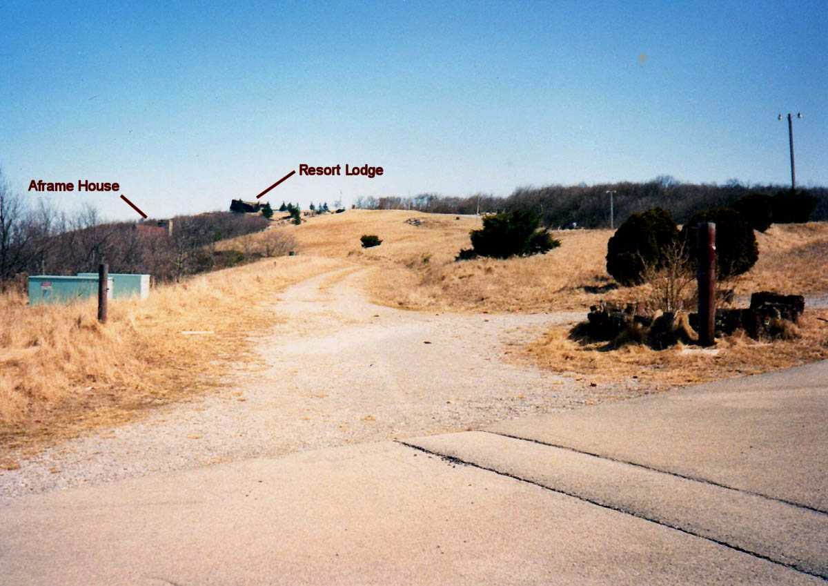
It has been just over two years since my first visit to the Camp Creek Bald area of the AT (Appalachian Trail) or as others know it, Viking Mountain. So, what better place for an AT Day Hike than a return, to this location, last week during our Spring Break in Tennessee. The first trip, back in April of 2013, Glen, Pete and I went up to the Camp Creek Bald Fire Tower and then north on the AT to Blackstack Cliffs and back. This past Saturday we returned, but this time Charlie, Glen’s big chocolate lab, joined us on the hike. This hike started at Jones Meadow and took the blue blazed road trail to the AT just above Blackstack Cliffs. Before I get to these hikes let me backtrack a bit. This mountain has always intrigued me. I had seen this mountain for years as it towers over the Greeneville area. I had always heard it called Viking Mountain, but when I started to learn more about places I wanted to hike I found out that the maps showed this peak, in the Bald Mountains, was actually Camp Creek Bald. The Viking Mountain name came from the old ski resort that once stood near the summit of the mountain. It was in the 1960s that the idea came for a ski resort on Camp Creek Bald. Besides ski slopes, there were a number of other things built on the mountain as part of this development including small chalets / rondettes (kind of like yurts) and a swimming pool. However, the centerpiece of Viking Mountain Ski Resort was the lodge and restaurant, called the Valhalla Inn. It even saw one ski season in 1972 the same year the resort closed. There is even a popular myth that Elvis Presley visited the resort by helicopter. Most of the pictures below I found on the RATtreks blog.
Viking Mountain resort site from the '70s, Valhalla Inn to the left.*
Picture from Jones Meadow in the 1980s.*
From Blackstack Cliffs circa 1980s.*
One of the old A-frame house*...
...inside*...
...these have all been removed.*
*All that is left is some tile from the pool...
...& NOT one of the old ski lift towers.
(*Photos from the RATtreks site).
The development with through a bunch of different owners and because of a number of factors the dream of a ski resort melted away (more details can be found in this Greeneville Sun story). The property is now in the hands of the U.S. Forest Service and besides the name, not much remains of the old resort except for one of the ski lift towers and some of the tile of the pool can be seen where it was located in Jones Meadow. Most of the pictures above I found on the RATtreks blog.
Snow covered Big Firescald Knob...
...& Camp Creek Bald from Greeneville.
The Bald Mountains from the Tusculum Trail.
So, this was a mountain I have wanted to visit for some time and when I learned that the AT crossed near its summit, Camp Creek Bald moved to the top of my places to hike list. So, when I was up for Spring Break in 2013 after a rainy week it finally cleared in the afternoon. So, Glen and I headed up Viking Mountain Road which is a nine-mile drive up the mountain. The first part of the road is paved and passes the Hemlock Hostel and a couple of fishing ponds called Dillard Place which is part of the Cherokee National Forest. Then at about but about four miles up it turns into a good gravel road. For those who are using GPS at about 6.5 miles up the name of the road changes from Viking Mountain to Bald Mountain Road. Right at the top, it turns back into a paved road where it reaches Jones Meadow.
Mom's place is near...
...the turn-off...
...Viking Mountain Road.
Another eight miles...
...to here.
The gravel part of the road up.
This is where most people park (and we did last weekend), but we continued on up to the parking area right under the summit of Camp Creek Bald. Now it is here that I need to mention that if you decide to head up this route you better have a four-wheel drive vehicle like Glen's truck because this is a rugged piece of road.
The road up to the Camp Creek Bald summit...
...is pretty rough.
Parking area near the summit.
Back in 2013, we were greeted...
...with ice.
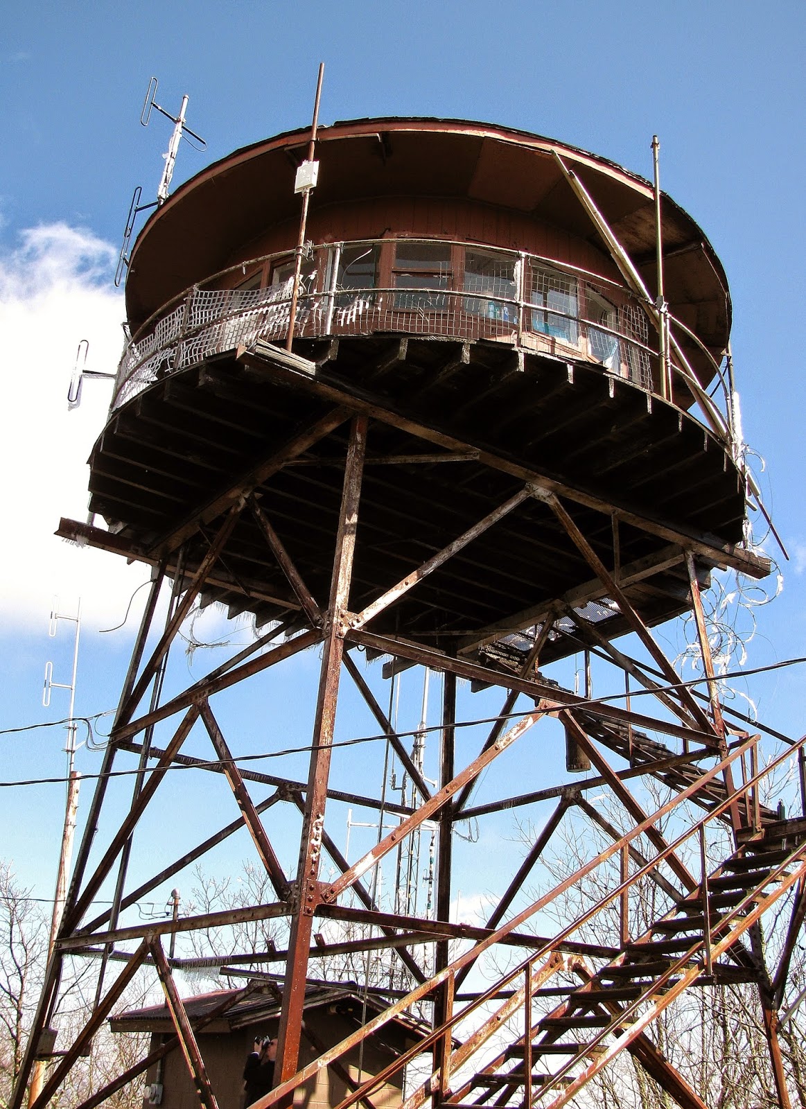
Like I mentioned above earlier in the day in the valley it had rained most of the morning, but to our surprise up on the mountain that prescription was ice, and it was beautiful. The other thing we noticed at the summit was the old fire tower. The Camp Creek Bald Fire Tower, built in 1928, is said to be one of the oldest remaining towers in the region and is on the list of the National Historic Lookout Register. The first AT thru-hiker Earl Shaffer stayed the night here in 1948. The original square live-in cabin was replaced in the 1960s by the unique round shaped one, which makes this steel tower noticeable from afar, but it was good to finally see it up close.
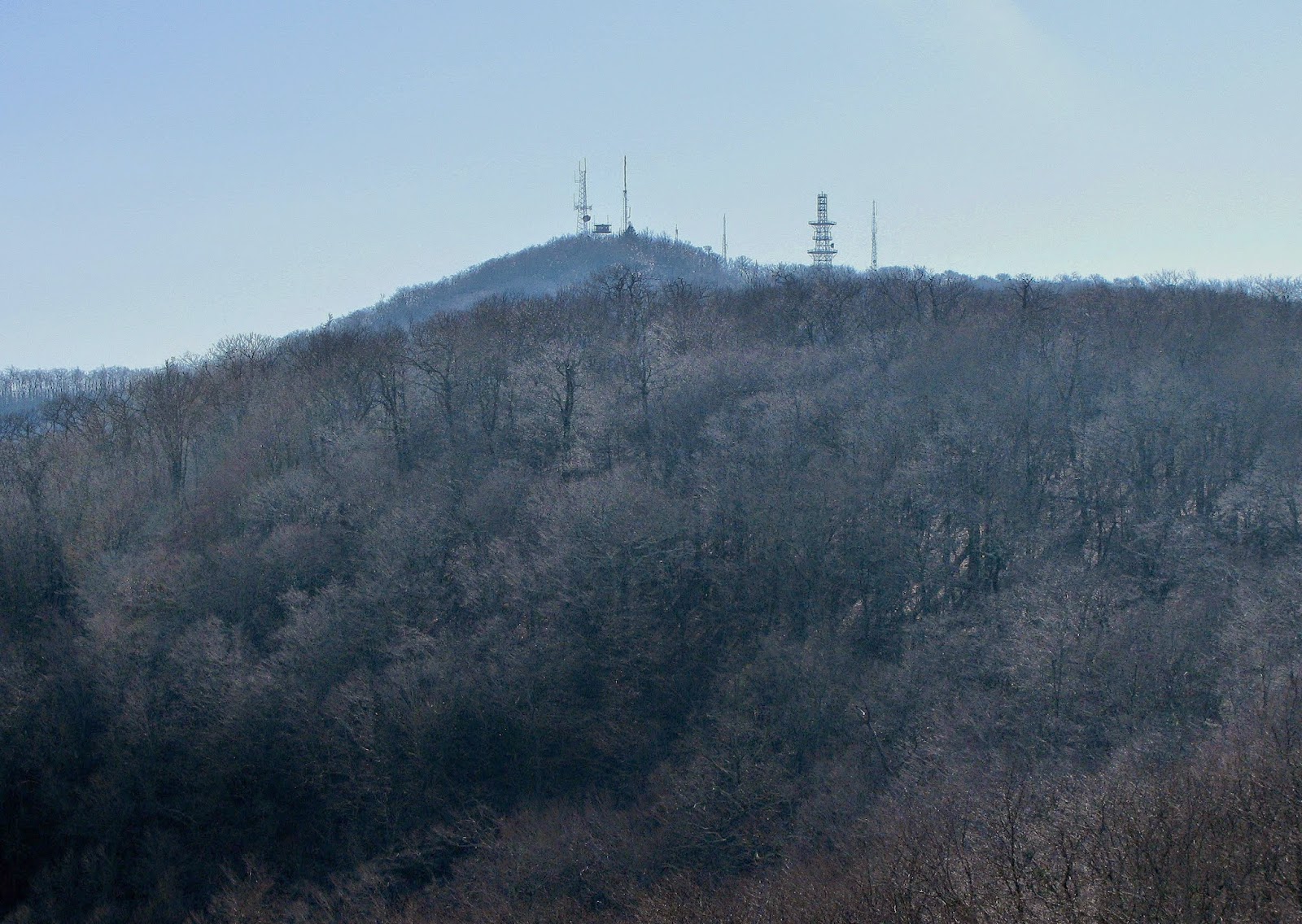
The round tower can be seen from Rich Mountain.
The fire tower from Jones Meadow.
View of the tower coming up from the parking area.
A better look at the round cabin.
That is a far as we could go in 2013...
...but in 2015 I think the radio club was there.
Today, with planes and satellites they are outdated, but some are still standing. Some of been turned into viewing decks while others are open if you are willing to climb, still others are totally closed. Then there are ones like Camp Creek Bald while the cabin level is not accessible (the way is blocked by razor wire) you can climb to the first level with a nice view. However, if you are lucky enough to catch the local radio club in the tower (Andrew Johnson Amateur Radio Club) you might get to enjoy the full beauty this tower provides.
Vista from the first landing of the fire tower.
Looking into...
... North Carolina Mountains.
Some of the towers & buildings at the summit.
On the building at the summit, someone painted a sign pointing the way.
View of another tower on the way to the AT.
The thing about Camp Creek Bald is the AT doesn't actually go over the summit but goes south just below it. Funny thing is Glen and I took a wrong turn when hiking down the trail that intersects with the AT. Luckily we hadn't gone too far down the wrong path. We finally made our way back and found the AT and headed north on the trail. Our destination was the Whiterock and Blackstack Cliffs which is just over two miles (one-way) on the AT. Since we got a late start because of the weather we did have to worry a little about it getting dark on us.
AT logo on a log points the way to...
...to the AT.
April 2013: There was snow on the AT.
One of the white blazes...
...& campsites on the trail.
Headed through some rhododendrons.
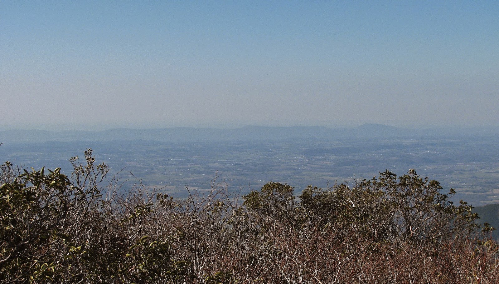
While I would describe this portion of the AT as moderate there were some rocky spots on the trail. After crossing a roadbed, intersecting trails and a campsite we reached the sign for the Whiterock Cliffs. If you know anything about the AT in this area it rides the state-line between North Carolina and Tennessee. The Whiterock Cliffs are fully in the Pisgah National Forest giving views into North Carolina. These cliffs offer a wonderful vista.
A sign that leads to...
...Whiterock Cliffs.
Camp Creek Bald from the cliffs.
Panorama at Whiterock Cliffs.
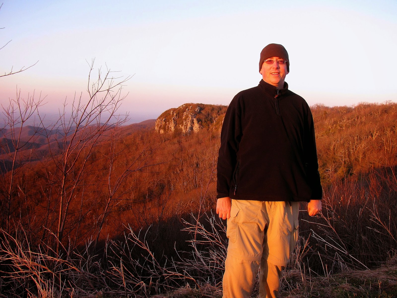
In 2013, a little heavier & no beard.
Another tenth-of-a-mile on the left is the path into the Cherokee National Forest and the Blackstack Cliffs. These Tennessee cliffs give views down the valley and of the town of Greeneville below. While we took the scenic route to these cliffs there is an easier way to them both via Jones Meadow. How do I know? Well, on my return trip to the mountain last week that is the way we came.
The sign to the "Tennessee" cliffs.
Camp Creek Bald from Blackstack Cliffs.
Glen at the cliffs.
Looking out...
...toward Greeneville.
On Saturday, instead of heading to the summit of Camp Creek Bald, our destination was the ridge-line of Big Firescald Knob. From Camp Creek Bald it is a three-mile hike to Big Firescald Knob, but from Jones Meadow, it is half that at 1.5 miles. So, we parked near the site of the old Valhalla Inn and hiked down the blue blazed road. Since this part of the hike is on roadbed one could drive part of the way down, but remember it turns rough pretty quick. There are a couple of huge mud holes on the road (which Charlie just loved).
Looking back over Jones Meadow to Camp Creek Bald.
Where we parked at Jones Meadow.
Charlie showing the way on the blue blazed road.
Charlie having fun...
...in the first mud hole...
...drinking out of the second.
At the 0.2 mile point of the hike, one sees a short path to an old landmark on this trail and that is the ruins of an old AT Shelter. I haven’t found its name or when it was abandoned now all that is left is one stone wall. One cool thing around it was an abundance of Spring Beauty wildflowers around it.
The remains of the old AT shelter.
Spring Beauties.
Another tenth of the mile down the road/trail led to a small parking area (for 4WD vehicles) where there is a split with the trails going left and right. Both are just over a tenth of a mile and lead to the AT. We decided to take the trail to the right because it has a blue blaze and decided to come back the other path on the way back. So, we reached the AT and headed north, the first place we passed was the path to the Blackstack Cliffs I mentioned earlier. Because we were a little pressed for time as we got a mid-morning start and Glen and his wife Donna were getting a reward later that evening we just didn’t have the time to visit the cliffs.
An area where the trail splits down to the AT.
Blue of the trail to the right.
Headed north on the AT.
We passed the trail up to Blackstack Cliffs.
Anyway, we headed down into Bearwallow Gap and here one finds two trail junctions. The first is where the Jerry Miller Trail comes up from the right. It is 4.5 miles path, listed as strenuous, from a trailhead of the same name in North Carolina of FS 111. The next junction is a couple a hundred yards up the trail where it splits again. Left is the old path the AT once took now called the Bad Weather Route, but we headed right up what is labeled the Exposed Ridge Route. This can be used as a lollipop loop, but we didn’t on this day. Oh, since the weather was perfect we went right.
With AT logo carved on an old tree.
They don't call it Bearwallow Gap for nothing.
Cool tree in the gap.
First trail junction...
...the path to the right is the Jerry Miller Trail.
The second junction...
...we went right.
Spot through the trees, Greeneville is visible.
A lot of work was done moving the AT over the ridge-line by a group called Konnarock Crew, an all-girl crew from Virginia, who worked alongside the Carolina Mountain Club and Greeneville Hiking Club to build the steps of the switchback we used to go up the mountain. One thing to point out is the trail passes through Mountain Laurel and Rhododendron, which would make this a nice hike in late spring.
Some of the rock steps up Big Firescald Knob.
The trail headed up...
...Charlie on the AT.
Mossy white blaze.
I will say about here I got what I call “Peak Fever” where you are just focusing on getting to the top of the mountain. This has happened to me before, like when I first went north on the AT up to Blood Mountain. Like that hike, this one remained me of that with a lot of shrub trees. While unlike Blood there is no iconic shelter letting you know you have reached the top, here the trail climbs out to an exposed ridge-line with an amazing view.
The AT has it exits the trees...
...to this vista...
...& this one.
This ridge-line is about half-mile in length with a number of spots to take in the fantastic view. I had read about this spot, but no-one really did it justice. It is flat-out one of the best vistas on the North Carolina/Tennessee section of the AT. It is better than Camp Creek Bald and I would even say the one at the Rich Mountain Fire Tower. Moving the AT over this ridge-line...good call!
The steps up to another outcrop.
Glen makes it to the outcrop.
In this vista, the valley there leads to Margarette Falls...
...Greeneville...
...panorama of the Tennessee Valley..
...Camp Creek Bald...
...North Carolina Mountains...
...Big Bald...
...& its summit...
Mt. Mitchell (center) & the Craggy Mountains (right).
Looking into North Carolina.
North Carolina &...
...Tennessee panoramas.
What makes Big Firescald Knob great, like the Roan Highlands, for example, it is a natural vista. Glen and Charlie stopped at one of the bigger outcrops which we hiked up too, but I headed another tenth of a mile further to the top of the knob. From here it gave an awesome view of Greeneville, where we came up from. Besides Greeneville and the Tennessee Valley on this ridge-line, one can look into North Carolina with views of Big Butt, Big Bald, Mount Mitchell, and the Great Craggy Mountains just to name a few. Oh, and one incredible view of Camp Creek Bald.
The Vista &...
...trail to the summit...
...with this view of Camp Creek Bald...
...& Greeneville.
Camp Creek Bald & Greeneville panorama.
Headed back to Glen & Charlie.
While taking in the view we were passed by a couple of thru-hikers. One guy had started in February but had taken the scenic route doing a couple hundreds of miles off trail in the Smokies. Another was a girl, who is a blogger for Appalachian Trials, which is cool. Well, after drinking in the view a little more we headed back.
One of the thru-hikers (she is the Appalachian Trials blogger).
Head back...
...on the AT.
Around rock face.
Another nice shot of the AT.
When we got back and passed Blackstack Cliffs we took the first trail up to the lower 4WD parking area. We then walked the road up to a point when we came to a clearing, a road goes left and a trail right. We had come down the road, but we took a path to the right which crests the hill at the Jones Meadow Vista. This was my second time taking in this excellent view, which was back in 2013, and it gives just as good a look of the Nolichucky River valley as the Blackstack Cliffs (but not Big Firescald Knob).
Back to the junction with Blackstack Cliffs...
...then the first trail back toward Jones Meadow.
View of Blackstack Cliffs from the second junction...
...with the trail up going right.
With this shot of the cliffs, you can see the trail we came up.
View of Greeneville from...
...from the site of the old Valhalla Inn.
Looking up to more of Jones Meadow.
Panorama of the sun setting on Blackstack Cliffs in 2013.
It was colder on our first trip than the second.
Sunsets on Camp Creek Bald.
Oh, you also get a great look at said Blackstack Cliffs and back over your shoulder the summit of Camp Creek Bald. One of the things, while researching this hike, I read that some rated this strenuous, but I think it is a pleasant moderate hike and I would include that even if you started at Camp Creek Bald. So from where ever you decide to start all of these views are easily attainable.
Midday view from Viking Mtn. Road Overlook in 2015...
...& with the sun setting in 2013.
The sun sets on this post.
There is one more vista on the way back down. Just before Bald Mountain Road becomes Viking Mountain Road again, there is a pull-off at a curve. It provides a wonderful view, which includes Rich Mountain and the Smokies. While the view Saturday was great it was a little more special on our first visit as we came down at sunset, which was wonderful. Whether you call it Viking Mountain, Bald Mountain or Camp Creek Bald this special place is well worth a visit.
Camp Creek Bald to Big Firescald Knob
My Take:
For Difficulty – 3 Stars
For Trail Conditions – 4 Stars
For Views – 5 Stars
For Solitude – 3 Stars
Overall – I said most of what I need above. It is a moderate hike with plenty of parking and great access to the trails. There are great vistas from Camp Creek Bald Fire Tower, Jones Meadow, White Rock, and Blackstack Cliffs and most of all Big Firescald Knob. We were there both times during the thru-hiking season and we pasted about seven hikers in the two hikes.
Pete’s Take:
For Difficulty – 1 Rabbits Paws
For Trail Conditions – 5 Rabbits Paws
For Views – 4 Rabbits Paws
For Solitude – 3 Rabbits Paws
Overall – I have to say I love this place. The hike is easy, so I didn’t have to hear the Lummox complain, which was a nice change, but for a seasoned hiker like me, it is a breeze. The AT is always in good shape and the connector trails are well blazed. It does have some nice vistas, but best of all it wasn’t too crowded and it was all hikers which were great.
The picture of the tower you say was part of the ski lift is an old AT&T telephone microwave relay site. It was never a part of the ski lift. It used to have huge feed horn antennas and wave guides on it that were removed sometime in the early 2000's. When the Andrew Johnson ARC members are in the fire tower the public is welcome to come in to visit. Unfortunately the tower has been vandalized several times with equipment stolen or damaged so access to the catwalk had to have severe measures taken because people were risking life and limb climbing around the trap door on the outside of the structure. In 2017 someone pulled down the wire and vandalized the inside again. The vandal destroyed the logbook that contained 16 years of entries left by visitors and club members that was irreplaceable. The tower is now under 24/7 video surveillance and a snapshot is uploaded to the AJARC website on a regular basis of the mountain view to the north.


 Pete’s Take:
Awesome photos and a great overview of the area. Thank you Russell! Next time, come spend a couple of nights at Viking Mountain Lodge!
ReplyDeleteThe picture of the tower you say was part of the ski lift is an old AT&T telephone microwave relay site. It was never a part of the ski lift. It used to have huge feed horn antennas and wave guides on it that were removed sometime in the early 2000's. When the Andrew Johnson ARC members are in the fire tower the public is welcome to come in to visit. Unfortunately the tower has been vandalized several times with equipment stolen or damaged so access to the catwalk had to have severe measures taken because people were risking life and limb climbing around the trap door on the outside of the structure. In 2017 someone pulled down the wire and vandalized the inside again. The vandal destroyed the logbook that contained 16 years of entries left by visitors and club members that was irreplaceable. The tower is now under 24/7 video surveillance and a snapshot is uploaded to the AJARC website on a regular basis of the mountain view to the north.
ReplyDelete