 |
| Woody Gap can get crowded. |
There are a lot of places to day hike on the
Appalachian Trail (AT) in
Georgia, but none maybe any more popular that the area around
Woody Gap. On this addition of AT Day Hikes I will cover areas on both sides of
this famous gap on GA 60. Also, as I did in a past blog I will post photos
showing some of the contrast between the seasons on this part of the AT.
 |
| The vault toilet. |
I could say this blog
is a year in the making, because my first visit to Woody Gap was a little over
a year ago. I have now been there on five different occasions. I guess I should first talk about the gap itself. Woody Gap is a
U.S. Forest Service (USFS)
Recreation Area about 14 miles north of
Dahlonega.
While not as developed as say Neel Gap, which has the
Mountain Crossing Outfitters,
it has more enmities than let’s say
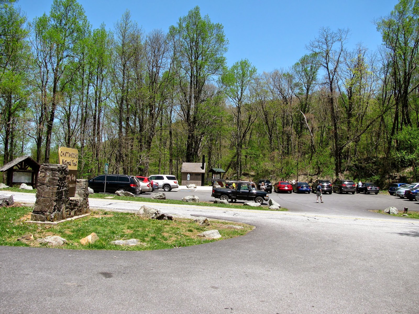
Hog Pen Gap. The Woody Gap has ample parking on
both sides of the highway. However, on weekends one might find both lots full.
Besides parking Woody Gap has picnic tables on both sides of
the road and a vault toilet on the
east side. I have mentioned vault toilets
before, what they are is in between a regular bathroom and a privy. This
means they don’t flush with running water, but you don’t have to through wood
chips on it yourself like with a privy. I will say I like them much better that
a port-a-potty (hell, I would much rather go at a privy). Funny, back in
October the toilet was closed during the Government Shutdown. Also, Woody Gap
features a nice southern vista in the west parking area. Oh, and one other
thing there is no user fee, which means it is free!
 |
| Late fall/winter vista from Woody Gap. |
 |
| Woody Gap spring view. |
.JPG) |
| Nov, 2013: More of the Woody Gap vista. |
 |
| Same view with a lot more green. |
However, the main draw of Woody Gap is that the AT cuts
right through its parking lots. This gap is the first-time that the trail cuts
across a paved road in Georgia headed north (and the last if you are coming
south). It has plenty of AT highlights like the big information board and the
famous rock which sit in grass of the east lot.
 |
| April, 2014: Deb with the Woody Gap sign. |
.JPG) |
| The AT information board. |
 |
| The Woody Gap Rock. |
 |
| November, 2013: With Woody Gap rock. |
While being a jumping off point for section hikes, because
it is just over 10 miles to Neel Gap and takes one over
Blood Mountain, the
main draw to Woody Gap is
Big Cedar Mountain. It is the reason Deb and I first
came here in April of 2013. Reading over my
Georgia AT Guide I discovered that
one of the most scenic spots on the AT in the Peach State is a place on Big
Cedar called
Preaching Rock. The best part about it is that the hike up is only
two miles round-trip and an elevation gain of almost 600-feet one-way.
 |
| Oct, 2013: Woody Gap is part of the WMA. |
 |
| Nov, 2013: This is just a little over a month later. |
.JPG) |
| The U.S. Forest Service info board. |
 |
| The distances from Woody Gap. |
 |
| Three seasons, the first is summer/early fall foliage... |
 |
| ...here is late fall/winter with no leaf cover... |
 |
| ...spring with trail blooming out. |
 |
| April, 2013: Deb headed up the trail. |
 |
| April, 2013: Headed up the AT... |
 |
| ...same spot six months later. |
I figured this would be a good AT starter hike for Deb. Up
to this point she had only gone to
Sawnee Mountain and I figured this would be
a nice step up and give her (and myself) a taste for future hikes, like at
Blood Mountain. The first part of the hike, as I had seen described, is a leisurely
stroll through hardwoods on a relatively nice part of the AT. After heading
north for a half-mile and passing Lunsford Gap one comes to the spot when the trail starts
to switchback up the mountain.
While the trail up both Blood and
Tray Mountains are much
more difficult, if you haven’t really hike a lot of these it provides a good
test and is quiet challenging. Also, for the uninitiated it provides a starter
course on something else you will find in the North Georgia Mountains…rocks.
Even if you haven’t hike the AT and have just been to Sawnee,
Kennesaw or
Stone
Mountains you know rocky trails are not just common in Georgia but the same is true for the
entire span of the Southern Appalachian Mountains.
 |
| Headed up in April, 2013... |
.JPG) |
| ...same spot in Oct, 2013. |
 |
| April, 2013: Another shot headed up... |
 |
| ...Big Cedar Mtn. (Oct, 2013) |
 |
| April, 2013: AT & white blaze... |
 |
| ...October, 2013. |
About halfway up one get their first look at the vista of
Big Cedar Mountain. To get a good look one must climb up a steep rock face. I
would say at this spot it is best to be careful, because one could easily lose their
footing. Also, something else to be careful of in spots during warmer months is
snakes. Two kinds of poisonous snakes are found in the North Georgia Mountains
Copperheads and
Timber Rattlesnakes. I know in October someone spied one
sunning on a rock on the trail up Big Cedar Mountain.
 |
| April, 2013: First outcrop. |
 |
| Second outcrop in April, 2013 with no foliage... |
 |
| ...here with leaf cover in early October. |
Just up the trail from the first outcrop is a second which
is a little more accessible, it also gives a nice view of the valley below.
This stretch is rocky, as the AT winds up through boulders and final crests to
a gorgeous open large rock face which signals ones arrival at Preaching Rock. This
is truly a spectacular view. The southeast vista give looks of
Horsetrough,
Cowrock and
Wildcat Mountains. Adding to the great vista is there is plenty of
room on the rock face for large groups of people, which on weekends is a good
thing. Unlike Tray Mountain which surprised me by how small its summit is this one is
as advertised.
 |
| Preaching Rock vista from April, 2013... |
 |
| ...early October, 2013... |
 |
| ...& late April, 2014. |
 |
| Deb thinking about Preaching. |
 |
| Old tree there in the fall. |
 |
| Still there in spring. |
 |
| Nov, 2013: Headed up Ramrock Mtn. |
 |
| Headed back up, May, 2014. |
This day hike takes one from the Woody
Gap to
Ramrock Mountain about mile-and-a-half south on the AT to a decent view on its rocky
outcrop. Looking south provides views of Horsetrough Mountain, Dahlonega and
Sawnee Mountain. The trail itself is not too difficult. However, when one reaches Tritt Gap there is a decent climb up to Ramrock Mountain of about 0.2 miles.
 |
| Nov, 2013: White blaze at summit. |
 |
| May, 2014: Same spot in spring. |
 |
| Rock outcrop vista, Nov, 2013. |
 |
| Brown November trail... |
 |
| ...much greener in May. |
 |
| Notice the white blaze... |
 |
| Someone added an N for north. |
 |
| Big rock in Nov, 2013. |
 |
| Still there in May, 2014 (where would it go). |
 |
| Nov, 2013: One of my favorite trees. |
 |
| Still there in May, 2014. |
 |
| Nov, 2013: Mountain laurel in fall. |
 |
| May, 2014: Laurel leaving & soon will be blooming. |
 |
| Nov, 2013: Yes, this is the same spot... |
 |
| ...as this (May, 2014). |
 |
| November, 2013. |
 |
| May, 2014. |
 |
| Nov, 2013: Back at Woody Gap. |
 |
| May, 2014: The signs of spring. |
I actually told a couple Sunday about a another hike less people know about that can be
done from Woody Gap and that is a hike up to the
Black Mountain Fire Tower.
The AT cuts across the south side of the
mountain, but, if you go up there, one will find at the top an old fire tower. The fire tower was built in 1949
and I had seen it on the way up to Woody Gap before and then looked up some
information about it on
SummitPost.org, including how the route up to the
tower. To get there one most walk about .10 of mile north on GA 60 to the gated FS
81. From here it is a mile up the Forest Service Road to the summit. Like any road bed these
hikes can be steep and there is some of that on this road to the top.
 |
| Have to walk the GA 60 to get to gate FS 81. |
 |
| Headed up the road bed. |
 |
| Road turns & heads to the summit. |
 |
| This deer is glad I am not a hunter. |
 |
| The grove of pines right under the summit. |
 |
| Black Mountain on left, dark area is the pine grove. |
Oh, before I forget there is the fire tower itself. In is a 33-foot
metal structure with a live in cabin. Unfortunately it is now covered with communication aerials
and because of that is fenced off, so one cannot climb up into the tower. With
the view just under it being what it is the tower vista would be spectacular. On the
way back down one gets a good look at the other side of Big Cedar Mountain and
off to the left a winter view of Woody Lake can be seen. This is a hike well worth the time, maybe one
day there will be a trail from the Woody Gap parking lot straight up to here.
 |
| First look at the fire tower. |
 |
| The Black Mtn. Fire Tower. |
Then at the bottom of the mountain at the junction of GA 60
and US 19 in Stone Pile Gap is a stack of rocks that has a legend behind it.
There is a historical maker on the site which says this is the final resting
place for a Cherokee princess
Trahlyta. It said that her tribe, who lived on
Big Cedar Mountain, had the secret to eternal youth. After being
kidnapped by a rejected suitor, Wahsega, she later died but Trahlyta dying wish was
to be buried near the magic springs. A custom arose first with Native Americans
and then with European settlers to drop stones on the spot where it is said
Trahlyta is buried for good fortune.
 |
| The historical marker... |
Whether one wants to go north or south on the AT or hike up
Black Mountain or just relax at one of the picnic tables, Woody Gap is one of
the better road crossings the AT makes and one of the best gaps.


.JPG)


No comments:
Post a Comment