When It Comes To Mountains It is Better To Be The Tallest
I thought about the difference in a mountain being the tallest in a state vs. the second tallest. This came to me standing in the parking lot of Brasstown Bald, the tallest mountain in Georgia at 4,784 ft. Rabun Bald, the second tallest mountain in Georgia stands at 4,696 ft. a mere 88 feet shorter than Brasstown Bald, but the difference in a visit to the two peaks is stark. Here are some photos to demonstrate this difference. The first picture will be for Brasstown Bald and will be followed by one from Rabun Bald.
The first difference is evident when you arrive at each peak. If coming from Atlanta one will finally reach GA Highway 180 and at Jack's Gap where you will turn on the GA 180 Spur to head three miles up the mountain. However, you are greeted by a large National Forest sign.
The sign at Jack's Gap where you turn onto GA 180 Spur.
At Rabun Bald first you have to drive to Sky Valley, GA, which is near Dillard, GA. You will turn off GA 246/NC 106 onto Kelsey Mountain Road for a 2.6 mile drive then turn on to Bald Mountain Road and follow it until the paved road ends at the Bee Gum Gap parking area. There is a much smaller sign that informs you that one has arrived.
The small trail sign at Bee Gum Gap shows that you have arrived at the start of the trail to Rabun Bald.
**Update 11-11-2014** On latest trip to Rabun Bald a sign was added at where one turns off Kelsey Mountain Road on to Bald Mountain Road. Unfortunately Bartrum is misspelled it should be Bartram. Still, I am glad the sign was added.
The new sign, but Bartrum is misspelled.
The next major difference one will notice is the size of the parking area. First there is the parking lot at Brasstown Bald and it can be described as ample.
Here is the parking lot at Brasstown Bald and it it large.
On the other hand the parking at Bee Gum Gap for Rabun Bald is mostly wide spots off the road which is about enough parking for five or maybe six cars. But, one good thing there is not a $5 (per person) charge.
Parking for maybe five cars at Bee Gum Gap, but remember don't block any driveways!
**Update 11-11-2014**
The parking at Beegum Gap is actually more than six cars.
Another huge difference is at Brasstown Bald you will find a gift shop, bathrooms and even a guy selling hotdogs.
While at Rabun Bald, there is no gift shop, bathrooms or hotdogs (if you want something to eat you better pack it in). However, there is a 4WD parking area which doubles as a campsite.
No gift shop, but here is the 4WD parking area & campsite.
Next up roads, it defiantly pays to be the tallest mountain because the road to the Brasstown Bald Observation Deck is a windy, but paved 0.5 mile road (closed to public) and one can take a shuttle bus to the top.
From Bee Gum Gap there is a 1.1 mile road, but there is a reason why I called the upper parking area a 4WD one. Rough may not fully describe the road. Oh, and there is no shuttle to the Rabun Bald summit.
The 1.1 mile 4WD road to the upper parking area.
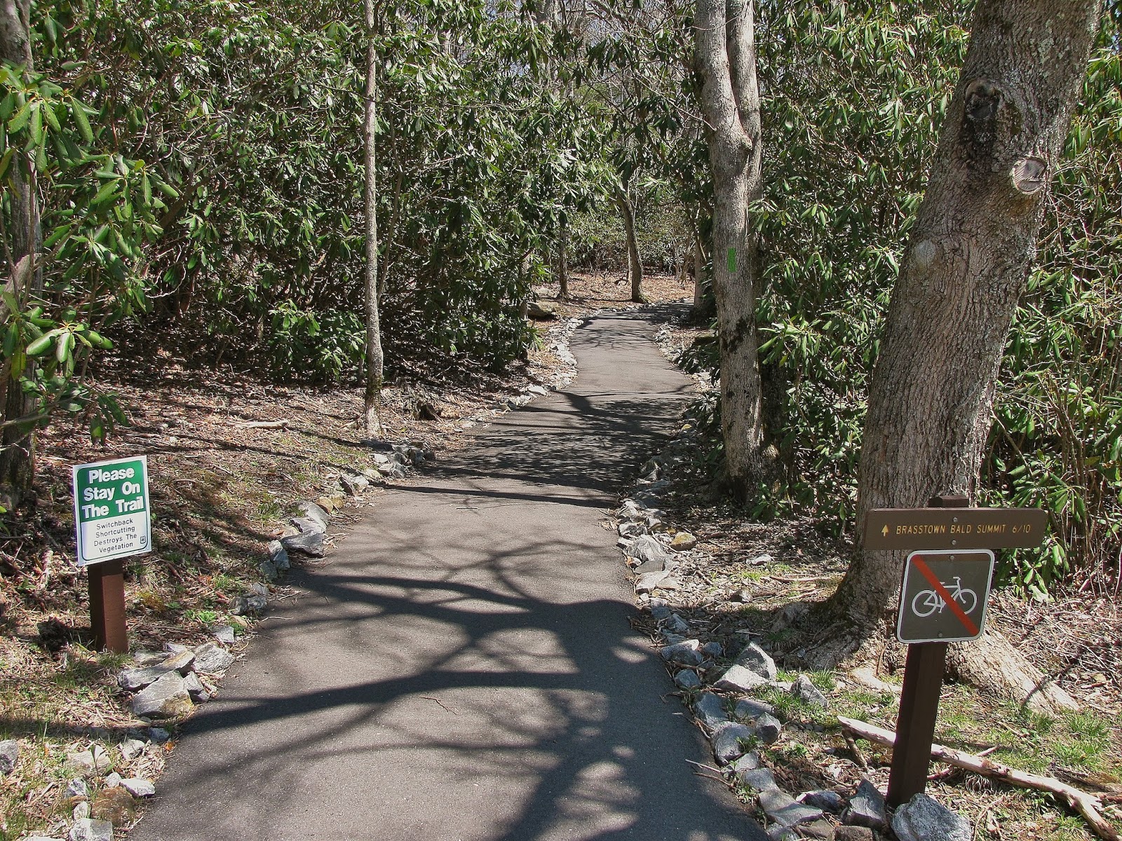
Now there is another way to get to the summit of Brasstown Bald, one can hike up, down or both. The trail is a 0.6 miles moderate to strenuous trail.
The trail up Brasstown Bald is a well maintained paved path. The trail intersects at about 0.1 miles with the Wagon Train Trail, which is a 5.6 mile trail to Young Harris College. At the end of the parking area of Brasstown Baldthe Jack's Knob Trail travels 4.5 miles to connect with the Appalachian Trail (AT).
One of the places where I think Rabun Bald scores points is the trail to its summit. The Rabun Bald Summit Trail is part of the Bartram Trail. This famous yellow blazed path is named after 18th-century naturalistWilliam Bartram and the trail closely follows the route he traveled from March 1773 to January 1777. One of the highest peaks it crosses is Rabun Bald.
When you arrive at the Brasstown Bald summit you will find a historical marker giving the story of Georgia's tallest mountain. It not just the tallest mountain that gets this treatment, but Blood Mountain also has one of these historical markers, it is not at its summit but at Mountain Crossings at Neel Gap.
Unfortunately, Rabun Bald has no such marker at the summit and as far as I can tell nowhere else. However, there are two stones indicting two trail that intersects near the summit Three Forks Trail and the Bartram Trail.
No historical marker, but two stones for the Three Forks Trail & Bartram Trail.
**Update 11-11-2014**
Here is new new sign near the Rabun Bald summit.
The starkest difference between the two peaks are the observation decks. Brasstown Bald has a huge observation platform with a large fire tower. Its size actually is more pronounced when you see it from another peak. It was built in 1965 and replaced a steel fire tower that was built in the 1940's.
The old fire town/observation deck at Rabun Bald is noticeable smaller. The old stone tower is one of the oldest in Georgia, built in the 1930's by the Ranger "Nick" Nicholson. When the fire tower was taken out of service the Youth Conservation Corps took out the cabin and constructed the viewing platform that is still there today. An interesting fact is the original tower at Brasstown Bald, built by the Civilian Conservation Corps in 1935, was a stone structure like Rabun Bald and remained until the current structure was built in 1965 (the steel fire tower was built next to the stone one).
The old stone tower, built in the 1930's, still stands at the summit of Rabun Bald.
Another thing that the Brasstown Bald Observation Deck houses is the summit's visitors center. Inside there is a museum which house a number of exhibits, including a theater, a train and two interactive animatronics, including one of the famous,"Barefoot Ranger," Arthur Woody.
The information desk at the visitors center.
The animatronic Arthur Woody. Along with "Ranger Nick" Nicholson are considered to be the two most important early figures in the history of the Chattahoochee National Forest.
One of those things that I like to find on mountain summits are the geological markers. Both peaks have markers and there is definitely a difference in their conditions. One reason might because at Brasstown Bald the geological marker is inside a small room in the fire tower, just to the right of the visitors center. If you want to see it one needs to ask to see it at the information desk.
Northwest vista from Rabun Bald (I didn't take this photo because the day I reached the summit it was banked in by clouds).
**Update 11-11-2014**
I took this east looking view on my latest visit to Rabun Bald.
So, if you are the tallest mountain more people want to visit and that results in bigger parking lots, visitors centers and paved roads. Georgia is not alone in its tallest mountain getting most of the love North Carolina and Tennessee are no different.
North Carolina:
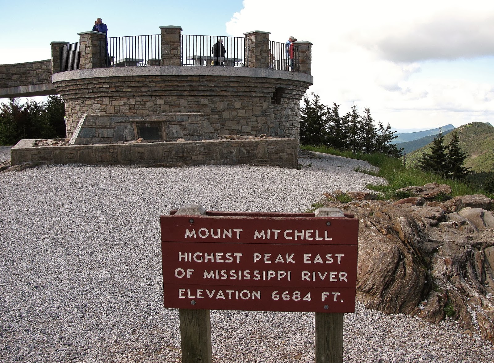
Mount Mitchell observation deck. Yes, there is also a visitor's center, gift shop and a restaurant down the mountain. However, you have to hike 0.6 miles to the summit.
That is the second highest mountain east of the Mississippi (& NC), Mt.Craig. Its summit can be reached by taking the Deep Gap Trail one-mile to its the peak. The parking lot in the foreground is for Mt. Mitchell.
To reach Tennessee second highest peak, Mount Guyot, you have to hike the AT to the summit area. The closest parking area is 10.1 miles at the Cosby Campground. I didn't take this photo either.
While the tallest mountains are the most accessible. The second highest peaks have a less traveled charm that makes actually a hike to them just as appealing.


No comments:
Post a Comment