Friday, February 14, 2014

Back In Time At Fort Mountain


Cohutta Overlook.


Well, with this week’s Snow/Icepocalypse over I turn back to my recent trip to Fort Mountain State Park. While not the best weather day looking back now this past Sunday was a good choice because this week has been terrible.
Vista from Cohutta Overlook.
Anyway, in the fall the drive up GA 52 would have been paved with apple stands with ripened fruit to sell as I had to go through   Since it was winter they were closed, however, I did have two overlooks to enjoy. The first I knew about it was the Cohutta Overlook. Unlike most where you just pull off the road, this one has you circled around the hill on which the overlook sits. From the five parking spots one has to hike about .10 miles to a nice overlook with a good winter view. The second overlook was a couple miles up the road across from the Overlook Inn (apt name since there is an overlook across the road). It was a good overlook with a nice information board about my destination Fort Mountain.
 
The Trading Post.
Speaking of Fort Mountain, when arriving at the park my first stop was at the visitors center called the Trading Post. Not all, but most visitors centers I have encountered have a stuffed black bear, I would like just once this not be the only bear I see in these parks. Anyway, the forecast was supposed to be partly cloudy, but when I got to the park it was cloudy with a touch of fog. So, I decided to start my day in the lower elevations with the Big Rock Nature and Fort Mountain Lake Trails, it must be said these places were still above 2,100 feet.

 So, I first hiked the Big Rock Nature Trail (yellow blaze), it is a ¾ mile moderate loop path that merges with the Gahuti Backcountry Trail (orange blaze) for half its distance. The highlight was the Goldmine CreekFalls. While the visible falls was small, between 15 to 20 feet it is much larger, in total about 400 feet. The creek travels about 2000 feet down the mountain. It is at the falls that the trail earns its moderate rating with a 30 degree climb.
Upper part of Goldmine Creek Falls.

Shows the falls as heads 2000 feet down.
Goldmine Creek Falls.

As the trail cross the road one goes down the other side and finds that it connects with the Fort
Mountain Lake Trail. This flat multi-use trail (hiking and mountain biking) measures just over a mile and like all of the lake trails I have hiked at Georgia State Parks relatively flat. If I had to describe the lake it is like a cross between Black Rock Mountain Lake & Lake Trahlyta at Vogel State Park. There are also a lot of information signs describing plants, trees and animals that can be seen on the trail.
Ft. Mountain Lake..
Stone Wall Marker.
So it was to the car headed to the top of Fort Mountain and why I came here, the ancient stone wall. A course since this is what gave the park its name the parking area was going to be large. One of the interesting things about the climb up the mountain is there are three trails that go up to the Stone Fire Tower and Ancient Stone Wall.
Each of these connects to the StoneWall Trail, which cuts across below the summit. I decided to take West OverlookTrail up.
The yellow blaze path is a little over half-mile up and splits off near the top with the red blaze trail going to the West Overlook, which was my first destination. This is a fabulous overlook with views of Chatsworth and Dalton to the west and I would say on a clear day Chattanooga and Lookout Mountain would easily be visible. On this day it wasn’t clear and Dalton was barely visible 15 miles away.

West Overlook.

Mountain with communication & fire tower.

Chatsworth & Dalton  in the distance.

Grassy Mountain.


Just thought this was cool.
Well, the West Overlook Trail becomes the North Stone TowerTrail as one heads north, which makes since. Anyway, as one climbs the staircase that is the yellow blazed trail it comes to a junction and the path to the right with red blaze and big sign pointing the way to the old Stone Fire Tower.
Trail to the Stone Tower.
Stone heart.
This tower is one of the highlights of the mountain. It was built in the 1930’s by whom else but the Civilian Conservation Corps (CCC). I am amazed on my travels of all the places the CCC built; hell as I have said before what would we have if these men had not built all of this infrastructure. Just goes to show government can do a lot right and none of it was for profit…wonderful! Well let me get off my soapbox and get back to the tower. It measures 38-feet
and was once use to spot fires. It once was open to the public, but the way to the top is now closed and the bottom stairs removed.
One interesting feature on the eastside just above the window is a stone heart.
It was put there when the tower was built by Arnold Bailey, who was one of the CCC workers. The 20-year old Bailey was hired as an “LEM,” or Local Experienced Man, in the CCC because of his background as a stone and brick mason. The reason he sculpted the heart was for his future wife Margaret Reece to profess his love for her. It must have worked because they were married for 59 years until Arnold passed away in 1994, so, Happy Valentine’s Day to everyone.

The old Stone Fire Tower.

Plaque on the tower.


Inside the tower.

Back of Stone Tower.

Eastside.

Built in 1930's by CCC.


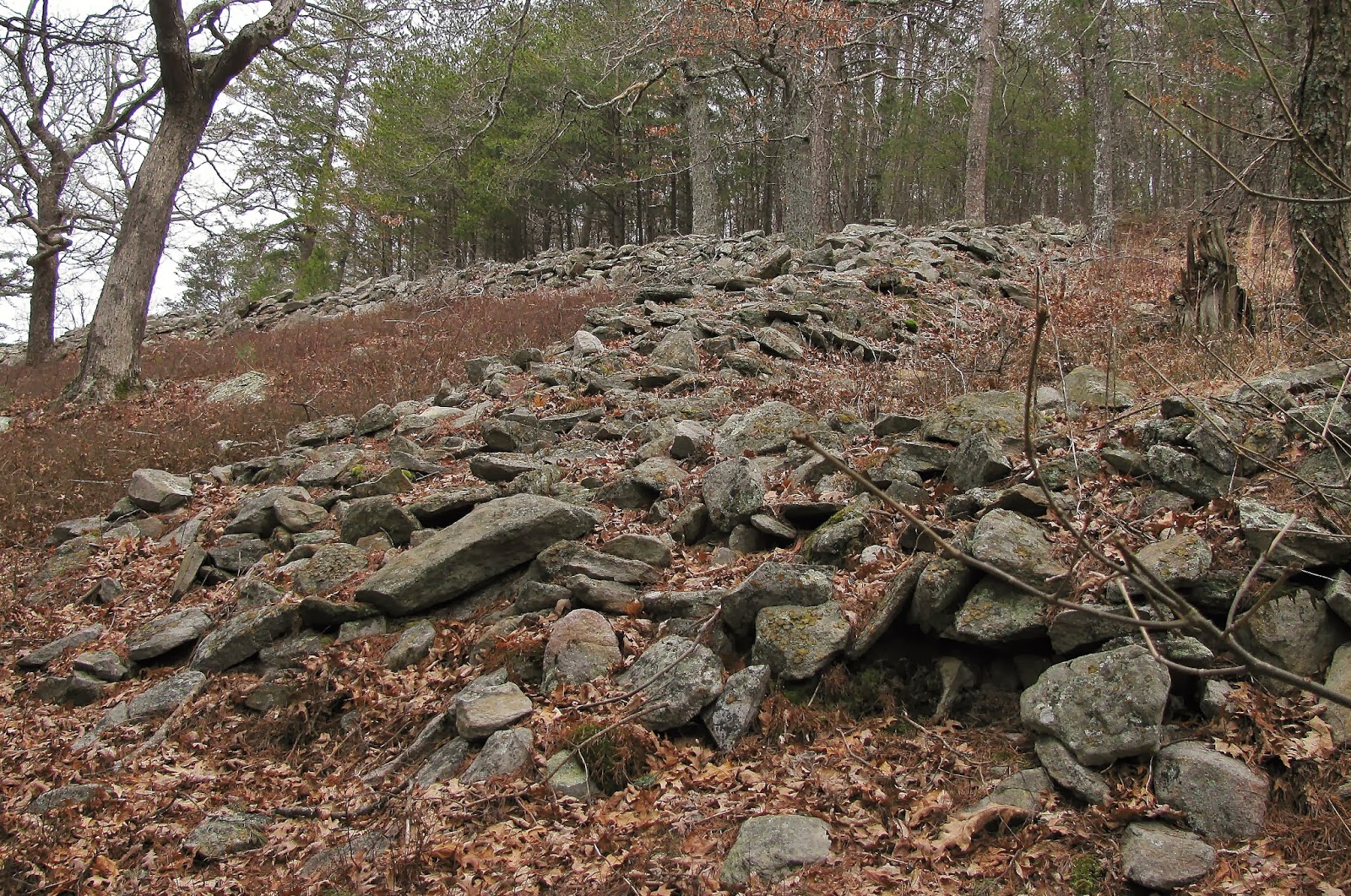
After some time and a quick bite to eat it was down the CCC Stone Tower Trail (built by take a guess). As you come down about 1/3 of the way you get your first look at the Ancient Stone Wall. While at first glance it might look like a pile of rocks. On further examination it is easy to see the design in the stone wall. It stretches 928 feet, varies in height from 3 to 10 feet & is 16 feet at its
The Ancient Stone Wall.
widest point, but on a map I found it was even large at one time. It has a number of pits and outcrops as it is easy to see why people thought it was a fort which led to the mountain getting its name.

Besides being the name sake of the mountain the Stone Wall’s most lasting feature is it is a complete mystery. It is not known
Map of the Stone Wall site.
when it was built, some speculate around 400 A.D. others say it was built later depending on whom you like to believe. That might be the biggest question, and there are a number of theories on how it got there.  On the stone display are two plaques with some of the theories on who built the stone wall. 

One tells the story that the Welsh explorers led by Prince Madoc came to the new world in 1170 A.D. landing in Mobile, Alabama and eventually made it to North Georgia. It is said they also built another stone fort near DeSoto Falls in Alabama and Old Stone Fort in Tennessee. Before one dismisses this theory, Cherokee chief Oconostota told John Sevier the legend about the Welsh crossing the Great Water and landing in Mobile Bay and building forts. Also there are stories about encounters with Native Americans who had pale eyes, red hair and spoke Welsh.
The left plaque.
The right plaque.
Another legend has it that the people who built the Stone Wall were the Moon-Eyed People, who might also went by the name Allegewi. Cherokee legend tells that these people inhabited the area when they arrived. They got there name, Moon-Eyed People, because they could see well in the dark, better than the Cherokees or any other Native Americans. There are two different legends about what happened to these Moon-Eyed People. The first said they were killed off by the neighboring Creeks. Another story says the Cherokee supplanted them. However, the stories say they were tall, fair skined and carried strange weapons.
From the lower trail, shows the snake like pattern.

Looking up at the Stone Wall.

One of the rock structures.

This also shows a snake design.

Another theory connects these walls with the ones found at Track Rock Gap and was featured on an episode of America Unearthed, which says they might be Mayan in origin. The newest theory says that it is not a wall at all but was built, in the shape of a snake, for ceremonial and astronomical observations. Some say it is connected to the snake mound builders in Ohio who have connections to a groupd called the Plumed Serpent People. Oh, and one more legend says it was built by the Allegewi who also might have built the the mounds in Ohio.

From the top trail rock in what looks like a circle.

What looks like a bastion.

One of the pits.
A cool tree.

A big stone that could have had ceremonial purpose.
Still, whoever built it, I found the site to be impressive. While the map only shows one trail there is actually two. One, which is blue blazed, goes along the top while the second snakes around the bottom. Each gives a unique perspective on the site. There are some cool features like the pits and 
ceremonial looking stones, but my personal favorite was a rock that looks like a shark fin. 
The shark fin rock

Another view of the shark fin.
The time came for me to move on and head back to the car. For the trip back I took the North Stone Tower Trail to the parking area. Once back at the car I had one more stop, the Cool Springs Overlook. It was down from the parking area and also served as the trailhead for the GahutiBackcountry Trail.
Gahuti Trail.

This is an eight-mile trail that winds around the park. The overlook is about .10 miles from the parking area and gives a nice east facing vista, which was helped by the fact the celling in that direction had lightened up.
Vista from Cool Springs Overlook.
Well, my day at Fort Mountain was over, but I still had one more stop. I decided to take a slight detour. Instead of taken GA 52 back to GA 138 and then to Dawsonville, like I did when I came up, I took GA 515 south better known as the Zell Miller Mountain Highway to Jasper, GA. The reason for this 30 minute detour is to see the
Mount Oglethorpe Monument. This monument once stood on top of Mount Oglethorpe and was erected in 1930 and at this time the name of the mountain was changed from Grassy Knob to honor James Oglethorpe. The mountain served as the southern terminus of the Appalachian Trail from its start in 1937 to 1958. After the southern terminus was moved to Springer Mountain the monument was neglected, damaged by lighting and defaced. It was moved to its present location in downtown Jasper and restored in 1998.

Mount Oglethorpe Monument.
James Oglethorpe.

Since the AT moved from the mountain it had been in private hands and not opens to the public. However, Sunday night after I got home I looked up something about Mount Oglethorpe and found out that a park is being built on top of the mountain. It is to be called the Eagle’s Rest and will feature two hiking trails one at the top which can be accessed by car and a second that will wind up the mountain to the summit. There will also be four view decks were there will be views in all directions, with one already built and finally a rock eagle sculpture 80 feet by 27 feet will adorn the south face. The park was dedicated on December 21, 2013 in a rock laying ceremony. From what I can gather the park is to open sometime this year, when I find out more I will right another blog.
Eagle's Rest on Mt. Oglethorpe.


Friday, February 7, 2014

History & Hiking on Kennesaw Mountain

Kennesaw Mountain.
Well on Sunday, Deb and I went to our good friends Clint and Cindy Arrington's Super Bowl party. So, anyone who doesn't know by now it wasn't a good night (because most of us were for Denver).
Because the game is long and we now live over an hour from their house in Kennesaw, they were gracious enough to let us spend the night. Anyway, being in Kennesaw gave me an opportunity to go to the top of the last of the iconic Atlanta Mountains, Kennesaw Mountain.
Sawnee Mtn. from Kennesaw Mtn.
For those who don't know, the other two mountains are the taller Sawnee Mountain, which stands at 1,946 feet and the more famous 1,686 foot, Stone Mountain. Kennesaw weighs in at 1,808 feet.
Stone Mtn. from Kennesaw Mtn.
Kennesaw Mountain like its neighbor to the north, Sawnee, is a ridge with two peaks. The first where we hiked to is Big Kennesaw and about a mile southwest from its summit is Little Kennesaw
Mountain (1,600 feet). It did cross my mind to hike out there, but we got a late start because of the weather, it rained most of the morning so that will have to be a future trip.
Anyway, both peaks factored in to what the mountain is most famous for and that is the Civil War battle that took place on it slopes. When you arrive at the visitors center cannons stand outside front of the building, which is just cool. Inside there is tent that shows how the soldiers of that area lived a gift shop and museum. There were some informative displays in the museum, like guns, flags, uniforms and equipment.  I must add that the staff at the visitors’ center was very friendly and helpful.
1841 12lbs. howitzer & 1861 Wrought Iron Rifle.
Museum display.
Still, our main reason for coming was to go to the top of “Big
Kennesaw.” Now for the uninformed there are two ways to reach the summit. First one can drive to the top and as the nice lady at the visitors center informed us was just opened, because it had been closed for fog that morning. The second way up, which is never closed, is to hike the one-mile trail to the top. Guess which we chose?
The first thing about the trail up it is wide and well maintained, I guess I shouldn’t be surprised since this is a National Battlefield and is under the care of the U.S. Park Service. Another thing was unlike
The more gentle Kennesaw trail.
Trail up Stone Mountain.
Stone Mountain, where the trail to the top was straight up, this one had switchbacks which make the trail easier and it was. The third thing I noticed was there was eeriness to the trail. I don’t know if it was because of the weather or just knowing that men fought and died on these slopes, but this mountain had a different feel, similar to Blood Mountain.
The feature on this mountain you don’t see on many others is the historical items. Whether it is the picket post, historical markers or cannons there was plenty of these all the way to the top. Near the summit area one first has to cross the parking lot and climb stairs to the observation deck, which is adorned with a plaque honoring the 14 Georgian Generals who served in the Confederate Army. It is here that the trail continues up to the summit. One will pass three cannons and the same number of historical markers, one details the fall of Atlanta, that can be seen in the distance.


Confederate Picket Post.
Parking Area & Observation Deck.
Plaque for 12 Georgian Confederate Generals.
Historical marker with Atlanta in background.
One of the cannons near the summit.

From the overlook to the summit there are spots where a wonderful view south of Atlanta, Buckhead, Marietta and the Chess Piece Buildings in Dunwoody can be seen. Out in the distance one also gets a good look at Stone Mountain. If you know where to look one can even spy Sawnee Mountain. It is obvious in summer that some of this view would be obstructed by tree cover. On this day it was just misty conditions that were the problem. To the north one is offered a nice view of Kennesaw and Cobb County. I would say on a clear day the mountains to the north would have been visible.

Downtown Atlanta.

Buckhead.

Marietta.
Chess Piece Buildings & Dunwoody.
Kennesaw.

The view is not the only reward for getting to the top. There was one more cannon and if you have ever read this blog you would know that another item I like to find at summits, U.S. Geological Markers, was easy to find this time. As summits go this was a nice one.
U.S. Geological Marker.
Cannon at the summit.

Well one of the cool things we ran across was a group of deer. The first time we encountered them was on the way up to the summit and I know Deb was excited because it was the first time she had seen any on the trail. However, on the way back we saw them again, this time right off the trail.
Deb with marker.

There was this time back in November on the old service road up to Black Mountain Fire Tower that I walked up on a deer and got as close as 20 yards, which at the time was the closest I had ever gotten to a living deer in the wild. This is nothing compared to this because I got to within 10 feet of these deer. In the photos I have posted here I barely had to use the zoom that’s how close I was. These deer were not a bit afraid of us. I mean they just looked at us and went back to eating, it was very cool.

Deer eating furgus off a tree.

Don't take my picture.

Yes, she noticed, but didn't run off.

So, that is about it, Deb was tried so we didn’t tour anymore of the battlefield park, but I would like to go back sometime in the future, because I enjoyed my time at Kennesaw Mountain. The other thing was that half-hour after we left the park it cleared off and turned it a sunny day, that’s Atlanta.
If you want to view more pictures checkout my Facebook photos.

Thursday, February 6, 2014

Flight's, Football & Ten FIDY


Well this was going to be a short blog I was going to do it before the Super Bowl, but I couldn't get my blog to work on the phone, so I didn’t get it done before the game. Then, after such a crappy game (unless you’re a Seahawks die-hard) I just didn’t get get around to it. Oh, the ratings here are the ones on my BeerAdvocate page.
My free Jekyll glass

So, this is the first real chance to get this blog post done. On Saturday, I went to the Beer Growler in Alpharetta and had what is called a flight.  It is four 5oz glasses of different draft beers. Usually they are set up light to dark beers, but my flight was all dark stouts. I have had all four of these beers before, but they are all top shelf beer. They were California’s Anderson Valley Wild Turkey Bourbon Barrel Stout, which was better this time than the first time I had it. The second was New York brewery Southern Tier’s Choklat, the third was from Michigan a seasonal Breakfast Stout from FoundersBrewery and the last was from homegrown Hampton brewer Jailhouse called Breakout Stout.


Growler of Ten FIDY (5.0) & free glass.
A flight of beers wasn’t all I got at the Beer Growler; I also had two of my stainless steel judges filled. The first was in my 32oz growler and was the Alpharetta brewer Jekyll and their Southern Sessions Blonde. The main reason I got this one was I got a free Mason jar glass with my growler purchase.
Outside Oskar Blues Brewery in Brevard.

However, the main reason I came in for a growler was to fill my big 64oz mini-keg in honor of the Super Bowl.  I will admit that I love my mini-keg and I only fill it on special occasions and the Super Bowl is one of them. So, it took a special beer and that means one of my favas (most likely my favorite) the Oskar Blues Ten FIDY. Since I was for Denver in the big game it also fits because Oskar is headquartered in Colorado, although this patch of Ten FIDY came from their year old brewery in Brevard, NC.  I have made two trips to the brewery and the tasting room the Tasty Weasel. I have to say the last time I went I had the Vanilla & Coconut version of the Ten FIDY.
Vanilla & Coconut Ten FIDY.
Tasty Weasel.
 It was great just like the regular Ten FIDY which is just a dark, glasses of goodness; well the game was a disappointment by none of my beers was. So, I if you haven't tried a Ten FIDY or any of the other beers I mentioned I say you can't go wrong with any of them.