This past Sunday I was scheduled to go to Johnson City for First Aid/CPR Training because I missed the one I was scheduled to do in February because of COVID. But since that was in the afternoon I had the morning to do a hike and I chose Laurel Run Park.
My First-aid/CPR Class in Boones Creek.
I chose Laurel Run because it wasn't out of my way. See my training was actually in Boones Creek which was before Johnson City. However, the main reason is there aren't too many places in early spring that has the wildflowers this small park in Hawkins County has. It also would allow me to run my drone, which I didn't get on my last trip here (I forgot the SD card). Since I only had a set amount of time, I planned to go to the main waterfall. But, I still went up the Overlook Trail on the slopes of Canebreak Mountain. There are always wildflowers going up and plenty coming down the other side. While I will try and do a Wildflower blog I have to say I didn't know if it was too early for a Drooping Wakerobin (Trillium).
Heading up the Overlook Trail.
The Overlook
(Clockwise) Carolina Spring Beauty, Wakerobin, Trout Lily, Fond Fern, Twinleaf.
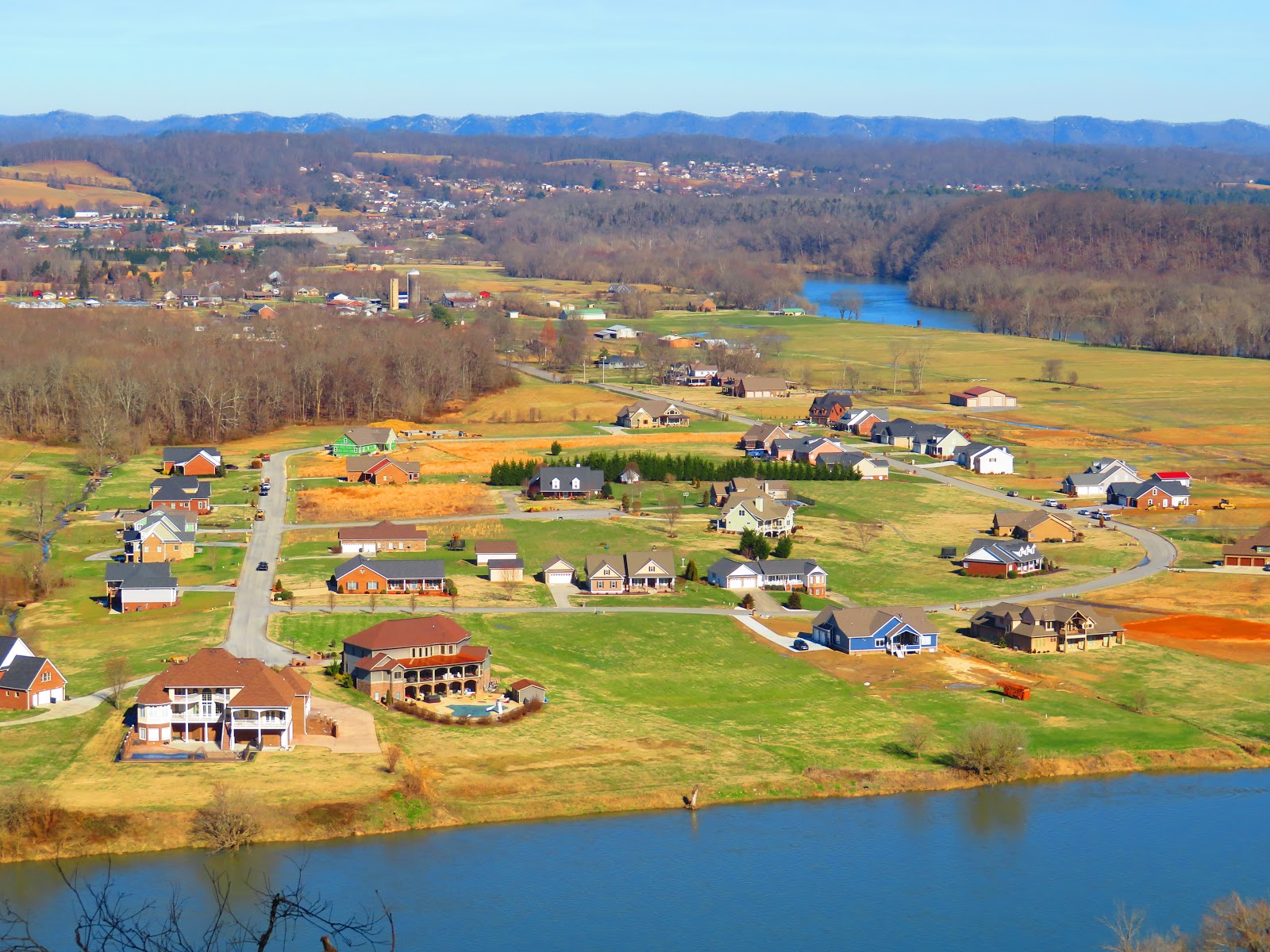
When I reached Laurel Run Falls I wanted to run the drone over it. Now I have run the drone around waterfalls before, but this was the most turbulence I have encountered. The drone would be pushed one way by a side draft, pushed by a down draft, and then lifted. No, other waterfall matched this. So, I decided to bring it in for a landing and as I was landing a side draft pushed into my chest and the drone crashed. It was okay and so was my chest.
When I got back I tested the drone and it was just fine. I flew it over the park and got some great views of the Holston River. My chest probably faired worse than my drone. I was happy and most of all so was Pete.
Hell yeah! The Hiking Machine is back and crushing trail! I dragged the Lummox out of bed and to Laurel Run Park. See, he had first-aid/CPR training on Sunday. Since it wasn't until after lunch I said "we're hiking!" The Lummox was still dragging from AT trail work. I was ready to go...Thursday afternoon. Anyway, while I shredded trail he got to look at wildflowers and crash his drone...LOL! Well, with that, there is only one more thing, I'm out...BITCHES!
This blog was going to originally be an On This Day Blog because this past weekend a year ago I made my first visit to Fall Creek Falls State Park. The 2019 Spring Tennessee Chapter Meeting of the Sierra Club took place here and it was my first time here. You could call it the Waterfall Park of Tennessee as it has seven large cascades. Now it is the rechristened Waterfalls of Appalachia (since the Blue Ridge just doesn't cover it)
The namesake falls, Fall Creek (256 feet) and its smaller sibling Coon Creek (250 feet) are accessible with a short hike down to an overlook of these plunge cascades. However, if you want a closer look there is a trail to the left that leads down a half-mile to the base of the falls. Since you are dropping into Cane Creek Gorge it is a steep climb down, but mostly with stairs. You will pass an impressive rock wall and house on the way to a viewpoint of the falls. Now if you are adventurous you can climb down to an up-close view.
You can get a look at three waterfalls just around the Betty Nunn Nature Center. You can go down to an overlook that gives views of Cane Creek and Rockhouse Falls. There is a trail to the base, the Cable Trail, but I didn't go down it because of the weather. But I did take the Gorge Overlook Trail for another good look at Cane Creek Falls. Off the trail, you can take another boardwalk down to a view of 40-foot, Cane Creek Cascade, but there is also a view from the footbridge on the Woodland Trail.
The last falls are at the end of Scenic Loop Road. Starting from the nature center one will pass the overlook for Fall Creek Falls then Millikan's Overlook, Buzzard Roost where you will also find Hidden Cascade. Finally, you will arrive at the 95-foot Piney Falls. It is a short hike to two different overlooks to the falls Ranger Randy calls his favorite. One last spot is a manmade falls, George Hole. So, if you want cascades there is no better place for Waterfalls of Appalachia.
When you are practicing Social Distancing and Shelter in Place because of the coronavirus it gives the Wood Booger time to write about something I love...waterfalls. Not just any waterfalls, but the place in Hawkins County that you will find the most Laurel Run Park.
The main waterfall gives the park its name Laurel Run Falls, but there are five others of different sizes and water flow. Since it is the closest hike to St. Clair that means I have hiked there many, many times. When I hike at Laurel Run Park I always start at the parking area near the bathroom, so that is where this one will start. It is a large parking area and you go up the road past the park map, on the right, and the park sign on the left. Then it is past the park office along the road and upper parking lot.
The actual trail starts past the parking area and you will know as there is trail sign at the bridge. The sign used to be further up the trail. You will cross two footbridges before a short climb up a wide trail to two old looking buildings. These were actually leftover from the movie the River's Edge and they are starting to show their age and have been boarded up. It is another short distance when you will come to the junction with the Overlook Trail.
This is a mile trail up Canebreak Mountain to an overlook and then back down to the Laurel Run Trail. You can go straight, but I norma;;y take the wide steep trail up to the overlook. It is an old roadbed, so it is very steep, but in Spring it has plenty of wildflowers. After a heart-pumping climb, you will reach the overlook which is a good time for a break with views of the Holston River Valley and Church Hill to enjoy.
There is a little bit more uphill before the trail heads back down and reconnects with the Laurel Run Trail. The trail now does a short uphill before heading downhill to a ford of Laurel Run Creek. How hard this is to cross will depend on how much water flow there is. If it is low a rock hop can be done. If higher then you will have to wade or do some fallen tree gymnastics. In a bit of irony, the harder the crossing the better the waterfalls will be...oh, a place for a footbridge?
The trail heads uphill with the beauty of the creek to the right. You will notice what looks like an old road than the trail straights out and as it tops a rise you will see the short side path to the right down to Laurel Run Falls. This is a 12-foot curtain-type cascade that you can view from several angles. It is a beautiful waterfall.
Most people stop here and return for a two-mile hike (sans the Overlook Trail which adds about half-mile more), but this is just the first. A couple of yards further you will come to a junction while a trail goes left, the official trailheads straight so continue that direction. In a hundred feet or so there will be another slight trail to the right. Here is a small five-foot cascade I call Little Laurel Run Falls.
Continue straight until the trail comes to a turn. here is where we get to the "unofficial" part of the hike. First, you will cross near where Kiner and Laurel Run Creeks come together. Once over you will cross some large blowdown and head up Kiner Creek. There is a faint manway up through here so follow it. It won't be long before you come to the first, I call Lower Kiner Falls. It is a seven-foot horsetail cascade that can vary in beauty by the amount of water flow there are spots where you will climb through rhododendrons before reaching Middle then Upper Kiner Falls. You will also notice a marker about here, so maybe they might make this an official trail? we will see.
You will know you are there when you reach the base of 30-foot Kiner Falls pouring over the cliff which is the end of the trail. As I have pointed out before this falls looks like a small Grotto Falls. Like it, you can walk behind Kiner Falls, but it can be tough in the Winter if it ices up. Oh, in dryer times it can be more of a trickle over the cliff than a falls
You can get another view of Kiner Falls by staying on the main trail back when you crossed the creek. It is about two-tenths of-a-mile climb where you will see a steep trail to the right. Be careful if you go down because you are 30 feet above Kiner Falls. You will notice before you get to this side trail another path down which you can use to get to the base of Kiner Falls. I would recommend going the lower trail on the other side of the creek as I described.
Anyway, the hike back is mostly the way you came, except you will go straight instead of going up the Overlook Trail. overall of this hiking clocks in just over three miles. Once back a trip down to the river is never a bad way to end the day at Laurel Run Park.