Monday, May 22, 2017

A Near Death Experience Highlights This Week's Down The Rabbit Hole


Pete here, but I must it almost wasn't the case!. Usually, Down the Rabbit Hole is about how I have to carry the Big Lummox on our hiking adventures. While I have a few of those stories, to come, I first must address my near death experience Wednesday as I was mauled by that Blanco Diablo...Bax!
We had just returned from a hike to Laurel Fork Falls, which I will talk about later, and for some reason, the Lummox decided to go pet Bax with me over his shoulder. Then that slobbering, fraidy cat Lester acted like he might finally come to the Lummox. So, when he leaned over to pet Lester, I suddenly found myself in the jaws of the farting fur ball Bax. I will say my life passed before my eyes and I thought about all of the mountains I hadn't climbed yet (like Mount Washington). However, as sudden as it started I was out of the mouth of that devil dog. While I will admit the Big Lummox saved my bacon, he was the stupid idiot that put me in harm's way in the first place! I  survived, but now I might hate dogs more than kids!


Now on to the hikes...on Monday we were on the kiddie ride of trails known as Panther Creek State Park. I know there was some talk of somewhere even easier, but Panther Creek isn't much on the difficulty meter to a Master Hiker of my caliber. Because of this, there wasn't much complaining, except when we had crawl though some blowdown. At least I only had to listen to one this time. But I like any trail time.


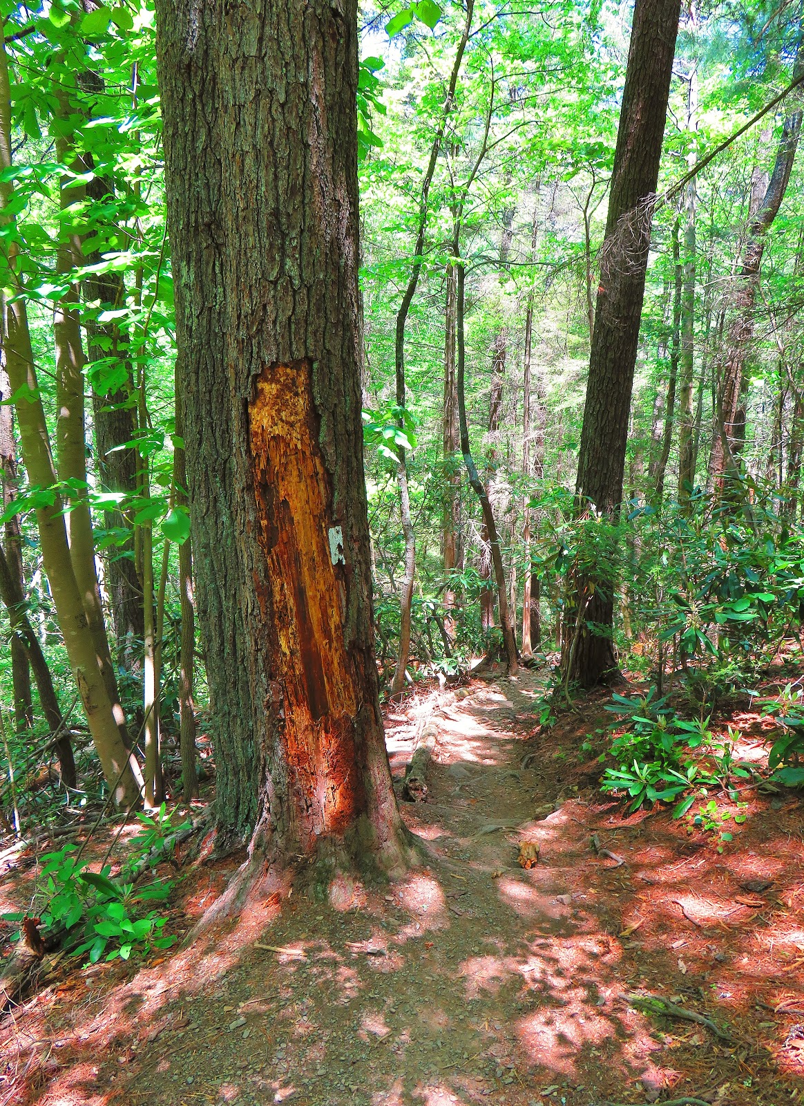
Now Wednesday was more my speed as it was AT (Appalachian Trail) time as we hiked to Laurel Fork Falls. Once again this hike was a walk in the park to a machine like me. But it wasn't a whine-free day. After enjoying the impressive Laurel Fork Falls we headed up a nice rocky uphill, but the Big Lummox didn't see the fun in this spot but instead complained about how hard it was. Well, it was for him. We then passed a couple of burnouts at the Laurel Fork Shelter, one said he was a thru-hiker. Speaking of thru-hikers I do have to add that it was good to be with a number of them who I admire because one day I hope to mold the Lummox into one...maybe in the future (when Hell freezes over). The day was almost ruined by my near death experience, almost.


Speaking of thru-hikers, on Saturday I attended the thru-hiking celebration that is AT Days in Damascus. I must say I would rather have been hiking a steep trail carring the Big Lummox (and others) to a great view, but since that ws off the table I couldn't think of any better place than to be with hikers close (but under my level). I even got to meet one of my heroes Jennifer Pharr Davis, now that women, is on my level! Oh, and I love the Hiker Parade!! Overall it was a good day even though I heard plenty of winning about hot it was. Instead of his feet the Lummox should have stuck his head in the water, then he would have known how it felt to be in Bax's mouth!


A Picturesque Day On The Way To Laurel Fork Falls


One of the most spectacular waterfalls in East Tennessee resides near Hampton...Laurel Fork Falls. Not only is it one of East Tennessee's best but it is also one of the finest on the Appalachian Trail (AT). On Wednesday, I hiked to this iconic waterfall, but it wasn't my first time. The last time I was here I came in via Dennis Cove back in April of 2014 (three photos below). However, that wasn't my first time at Laurel Fork Falls, back in my college days I hiked up to this 50-foot cascade starting near Hampton and heading up the Blueline Trail to the AT. This is the way I headed up Wednesday, because it had been over 25 years since I had made this trip, so it was almost like I had never done it before.


The first thing, there was no drama at the trailhead (see here) and I headed up the Blueline Trail which is a mile-long path to the AT. The first part of the trail is relatively pleasant, but be sure to watch the trail markings as there are trails that break off (but they end up reconverging).


The next section of the Blueline parallels, you guessed it, Laurel Fork and it has some really great views and a couple of places to take a dip. There are a couple of more spots that are not well marked, with some side trails. While there are no markings, one seems like (from stuff I looked up) an unofficial High Water Trail. At some point, the Blueline Trail crosses into the Pond Mountain Wilderness, but there is no sign like on the Dennis Cove side.


It is not long before the Blueline finally dead ends into the AT. While the trail sign points the way the southbound AT heads right to the falls. The first part of the AT is similar moving along Laurel Fork, crossing a pair of impressive footbridges. Along here there are also some great campsites.


It is long before the AT heads uphill (over a half-mile on the AT) and moves across a ridgeline above the Laurel Fork Gorge. There are some nice views, plus some Mountain Laurel and Piedmont Rhododendron. In two-tenths of a mile, the AT comes to the junction with the High Water Trail. This blue-blazed trail leads left and passes Laurel Fork Shelter and should be used if there is high water in the gorge.


I went right, following the white blazes, down into the gorge. I will say that the next  For the next six-tenths of a mile the AT follows Laurel Fork with the first half offering some nice access points to the water. The second half show why there is a need for the High Water Trail as the AT hugs a rock outcrop just above Laurel Fork. I got to give it to the Trail Maintainers of the Tennessee Eastman Hiking and Canoeing Club (TEHCC) here this is a good piece of work.


It is long that one first hears and then it can be seen through the trees...Laurel Fork Falls. While the water flow was great the last time I was here it was even better on Wednesday, Also, this time it wasn't as crowded as the only people there were AT Thru-Hikers, which Pete liked. Oh, and there wasn't near the trash I saw last time here. One interesting thing I noticed to the right at the bottom of the falls the rock looks like a face...cool! I spent a little longer here than attended, but it was worth it.


 It was long before it was time to head back, but instead of heading north on the AT I continued south. As I wrote before this climb up the gorge is steep and rocky. Once at the top, I turned left, leaving the AT, and heading back on the High Water Trail. This trail follows some of the old railroad cut, but it does have some better not loose your footing spots. The final section of the trail comes to the Laurel Fork Shelter.


This shelter is a small one that sleeps six and while it has water there are no bear cables. Also, as TEHCC shelters go it is pretty primitive, there is no privy (except for a shovel). I met two hikers there one was a thru-hiker and the other was a buddy who came to visit from Kentucky. They had a third friend, but she was getting water I think here name was Mary Jane.


From here it is not far back to the junction with the AT. From here it is an out-and-back hike the only thing differents were instead of passing through hikers (like on the way up) it was day hikers (mostly college students) which I expected. The second, I took one of the side trails on the Blue Line and it merged back it the blue blazed trail.


I will have to say this turned out to be the right choice for this hike, I just wish I could remember the one I did before. There might have been a Mary Jane on our hike.