 |
| Blood Mountain |
 |
| 2013: Deb with sign that is gone. |
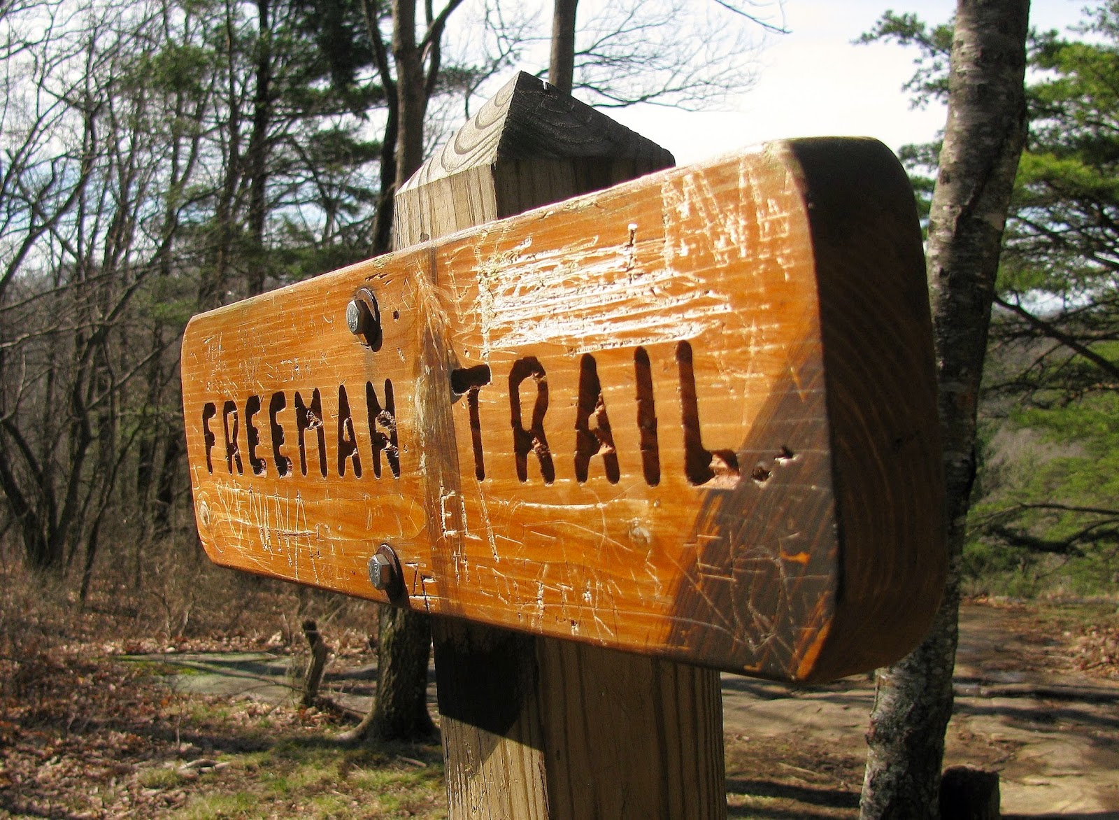
So, Saturday Deb and I ventured out to Blood Mountain...again. I talked a little about our trip here, but this was her second climb up the mountain. Her first to Blood Mountain like mine was back in April of 2013. We did the traditional hike up the AT and back down which is just under five miles. Since that first trip out I had tackled the mountain on three other occasions. I summited the mountain three different ways on each visit. In October of 2013, I did what was called the Blood Mountain Loop. I have talked about this before, but for the uninitiated all Day Hikes from Neel Gap must start at the Byron Reese Memorial 1/3 of a mile from Mountain Crossing at Walasi-Yi. So, the Blood Mountain Loop start on the Byron Reese goes up to Flatrock Gap. From there you cross the AT and take the Freeman Trail about two miles to Bird Gap where it reconnects with the AT. From there you head north on the AT up a less steep climb (than southbound) to the summit of Blood Mountain. Then head back down the mountain on the AT to Flatrock Gap and down the Byron Reese to complete the lollipop loop. This hike is six tough miles.
 |
| One of the signs at Neel Gap from October 2013. |
 |
| October 2013: Less crowded CCC Shelter in the autumn. |
 |
| October 2014: At the AT junction at Jarrard Gap. |
 |
| My group about to enter Blood Mountain Wilderness in December. |
I did this loop again on my last visit, back in December, with my Hike Georgia group, except we went the opposite way going up the steeper south face of Blood Mountain and then coming back on the Freeman Trail. This way is harder than doing the loop northbound. Now on my third trip up Blood this past October I came up from Lake Winfield Scott. This is the longest and toughest way. I went in to more detail here but let just say that coming up the Jarrard Gap Trail to the AT and then coming back via the Slaughter Creek Trail clocks in at about nine miles. Anyway, this past weekend Deb and I did what I now call the Blood Mountain North Loop (which I did in 2013).
 |
| Trailhead for the... |
 |
| ...Byron Reese Trail. |
 |
| With Blood Mountain Wilderness sign. |
 |
| Crossing Shanty Creek... |
 |
| ...here is lower Shanty Creek Falls. |
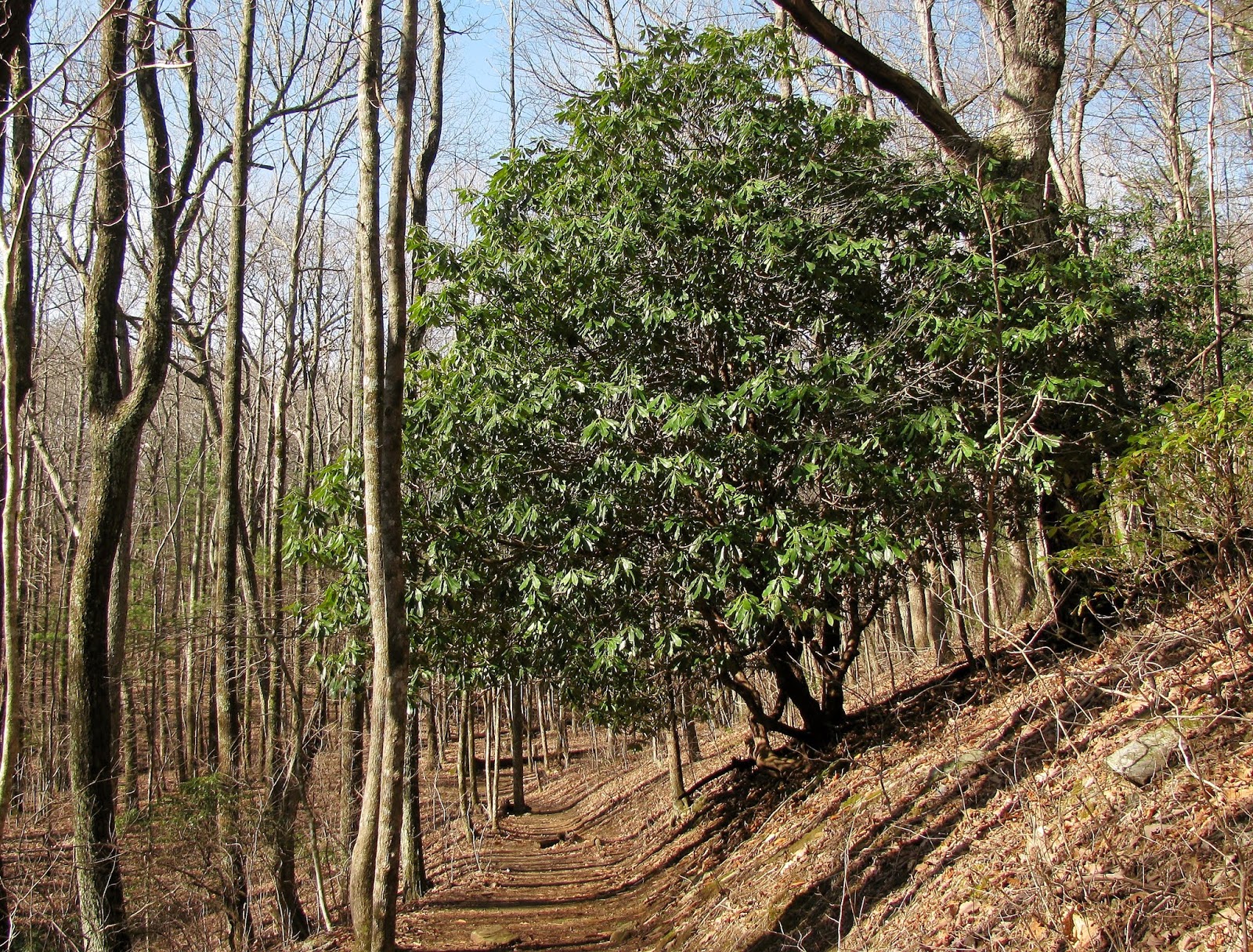 |
| Love this Rhododendron. |
 |
| Flatrock Gap |
 |
| Deb explains the way we came. |
 |
| Vista a Flatrock Gap. |
Deb didn’t like the climb up the south face of Blood Mountain. I have said before it is rocky and steep. I told her that from my experience the north loop is the easiest way up. Another reason I like it is that there is less traffic. Most of people who do this loop are hikers. Now let me say it is six miles (which is Deb’s hike limit) and you do have to climb over 2,000 feet. While longer that the regular out and back the climb up the north side of Blood is not as rocky or steep. Let me add that any trails around Blood Mountain will be rocky that is just a fact of life on this mountain. I say this because halfway down the Freeman Trail Deb was questioning my trail choice. In my defense I did tell her it wasn’t easy and it was longer.
 |
| Next up! |
 |
| Vista from the Freeman Trail. |
 |
| There were some rock spots... |
 |
| ...to Deb's displeasure. |
 |
| There was some uphill.. |
 |
| ...it is not too hard. |
 |
| Another Freeman Trail vista. |
 |
| Blue blaze of the Freeman. |
 |
| There was a lot more water on this trip. |
 |
| I spotted someone who cheated, you know who you are! |
Let just say Deb had cursed the mountain (and me) a few
times on us reaching Bird Gap. From here it just over a mile to the summit,
while I told Deb it was tough and don’t think she thought it would be like this.
At least I knew the way because on this day a number of people who passes us on the Freeman went the wrong way at the Slaughter Creek Trail junction. I guess it can be confusing there, but on my first trip up I had the AT Guide Book and guessed the trail headed right was going up was the way to go I didn't have a problem. Deb even asked if we where going the right way and I said yes this is my third trip up so I know where to go, but others didn't.
When we finally did make it to the summit she admitted that the way we came this time was easier than our first hike up in 2013, making me feel vindicated. Speaking of the summit when we reached the top it was crowded. Now I expected it to be busy, every time I have been up there have been people. Even in October of 2013 on a windy and cold day there were a number of hikers. But nothing likes the crowds on this day.
 |
| The AT starts up Blood Mountain. |
 |
| Some people get confused at this junction... |
 |
| ...with Slaughter Creek Trail... |
 |
| ...just remember go right up the steps. |
 |
| Camping spot. |
 |
| Well worn... |
 |
| ...AT. |
 |
| There are steps on the north side. |
 |
| Lake Trahlyta at Vogel State Park. |
When we finally did make it to the summit she admitted that the way we came this time was easier than our first hike up in 2013, making me feel vindicated. Speaking of the summit when we reached the top it was crowded. Now I expected it to be busy, every time I have been up there have been people. Even in October of 2013 on a windy and cold day there were a number of hikers. But nothing likes the crowds on this day.
Like I said I expected crowds it was one of the reasons we got to the
Byron Reese before 10 am. On nice weekends, like this day, the ample parking
area can fill up. Heck, there is even a sign telling of other places to park
and access Blood Mountain.
On the way to up the Freeman Trail we passed or were passed by at least 12 people. On my two previous trips on the Freeman I had passed two. Deb told me something I hadn't thought of it is Spring Break time. So, at the summit you had a mix of thru and day hikers plus spring breakers and around the area of the CCC Shelter and Picnic Rock it was packed, so much so Deb and I hiked on to find a less crowded place.
 |
| The lot was filling up at 10am... |
 |
| ...here are the other places to park. |
On the way to up the Freeman Trail we passed or were passed by at least 12 people. On my two previous trips on the Freeman I had passed two. Deb told me something I hadn't thought of it is Spring Break time. So, at the summit you had a mix of thru and day hikers plus spring breakers and around the area of the CCC Shelter and Picnic Rock it was packed, so much so Deb and I hiked on to find a less crowded place.
 |
| Last blaze to the... |
 |
| ...crowded summit. |
 |
| I did get a shot of Brasstown Bald. |
 |
| The vista at Picnic Rock... |
 |
| ...I cropped out the people. |
 |
| Another shot of CCC Tower. |
 |
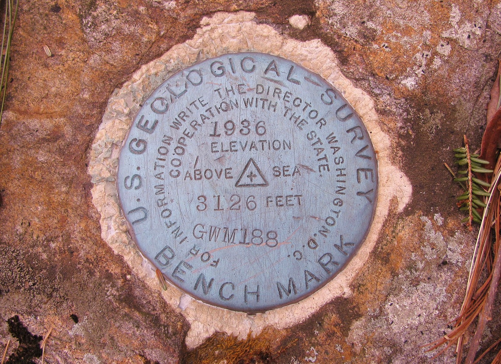
| U.S. Geological Marker... |
 |
| ...Deb with it... |
 |
| ...me too. |
 |
| Wolf Laurel Top, Cowrock & Wildcat Mountains. |
 |
| Rocky & Tray Mountains. |
 |
| Rabun Bald. |
 |
| Headed across the summit. |
 |
| From another outcrop... |
 |
| ...& Deb at it. |
 |
| Looking west. |
One of the great things about the Blood Mountain summit is that it's large so the crowds can spread out. Unlike let say Tray Mountain were it starts to get crowded with five people you won't notice that number on Blood. I know we passed more than 30 people. We finally stopped at the last outcrop
(or the first if you are coming up south on the AT) and I will argue the best.
There are great views all across the summit, but this one offers a 180 degree panorama
with views of Yonah Mountain, Piney Mountain, Sawnee Mountain, Atlanta, Black Mountain,
Big Cedar Mountain and Mount Oglethorpe and many others. It is one of the best
views in the North Georgia Mountains. With this view we stopped and ate lunch
while watching the view and thru-hikers pass by.
 |
| We came down to... |
 |
| ...the wide panorama from my favorite spot. |
 |
| From here you can see Yonah Mountain... |
 |
| ...Black & Big Cedar Mountains... |
 |
| ...Sawnee Mountain & Atlanta... |
 |
| ...Mount Oglethorpe. |
 |
| Deb at the outcrop. |
 |
| "The Mountains are calling & I must go!" |
 |
| Some of the many thru-hikers we met. |
 |
| One last look...ahh! |
 |
| Going up is harder than coming down... |
 |
| ...Deb going up in April 2013... |
 |
| much happier gone down, Saturday. |
 |
| Time to go. |
The number of people means there were a lot of them that
either had never been out in the wilderness or just have no respect for the
mountain (or anything). I am going to
write a separate blog on this soon (very soon).
Oh, one other thing the trail was wet and sloppy. I was surprised by the amount of water we had to cross on the Freeman Trail. The recent rains have fed the streams on the mountain this rain also means a wet AT and with the number of hikers out the trail was chopped up and sloppy. The Georgia Appalachian Trail Club will have some work in the weeks to come.
Anyway, we passed even more people either us going by them, they going by us or more people coming up the south face. The most interesting ones was I believe, a church group of kids and there was one boy who was way in the back who was a little over weight (to be kind). I don’t know if he was going to make it and whether he should be trying. Before we got back to the trailhead I spotted the first wildflower of spring, a Spearleaf Violet. Anyway, when we reached the parking area at the Byron Reese Memorial that it was almost full and there was evidence that at one point it was overflowing.
 |
| A blog is coming! |
Oh, one other thing the trail was wet and sloppy. I was surprised by the amount of water we had to cross on the Freeman Trail. The recent rains have fed the streams on the mountain this rain also means a wet AT and with the number of hikers out the trail was chopped up and sloppy. The Georgia Appalachian Trail Club will have some work in the weeks to come.
 |
| Headed down the AT. |
 |
| Vista on the way down. |
 |
| Pyramid rock. |
 |
| Laurel tunnel. |
 |
| More of the trail down... |
 |
| ...which means steps. |
 |
| Here... |
 |
| ...here are two examples of the sloppy trail. |
 |
| Deb was glad she only had to come down this way. |
 |
| Big Rock... |
 |
| ...with this boulder I love! |
 |
| Trail to Neel Gap. |
Anyway, we passed even more people either us going by them, they going by us or more people coming up the south face. The most interesting ones was I believe, a church group of kids and there was one boy who was way in the back who was a little over weight (to be kind). I don’t know if he was going to make it and whether he should be trying. Before we got back to the trailhead I spotted the first wildflower of spring, a Spearleaf Violet. Anyway, when we reached the parking area at the Byron Reese Memorial that it was almost full and there was evidence that at one point it was overflowing.
 |
| Big rock down from Flatrock Gap. |
 |
| Upper part of Big Shanty Falls. |
 |
| Deb headed down the steps... |
 |
| ...of the Byron Reese Trail. |
 |
| First wildflowers of the season...Spearleaf Violet. |
 |
| Shanty Creek. |
 |
| Deb conquers her Everest! |
 |
| The lot full today... |
 |
| ...even down the road. |
We ended the day with visits to Sunrise Grocery, about five
miles west down US 19 toward Blairsville and then at Mountain Crossing back at
Neel Gap. When we stopped there in the morning it was busy, but nothing like
now. A lot of the thru-hikers we saw at Blood Mountain had stopped for the evening
at Mountain Crossing and its Hostel. There was this one girl we had passed earlier
when we spotted her in the store she was trying to get a problem with her feet
fixed, black toe. Black toes are coming when hiking and more so with
thru-hikers. I had this happen to me this time last year coming down Levelland
Mountain. However, Deb said instead of two toe like me hers was multiple on
both feet and they were bleeding. I wish her the best of luck because it takes
a while for them to heal. Anyway, that finished another hike at one of my
special spots, Blood Mountain.
 |
| Took Deb to Sunrise Grocery. |
 |
| Last stop Mountain Crossing... |
 |
| ...there were plenty of thru-hiker. |
 |
| There is still this view. |
 |
| I don't know how I missed this. |
 |
| I would rather sleep. |
 |
| Deb & the mountain. |
No comments:
Post a Comment