GSMNP Jumpoff To Charlie's Bunion From Newfound Gap
Hiking can
be a lot of things, I even went over the Top 5 Reasons I love hitting the trail
there is one that I left out and that can be it is therapeutic and that is what
my latest visit to the Great Smoky Mountains National Park (GSMNP) prove to be.
As I have talked about a number of times I had a trying month after my
apartment flooded and having to move my stuff back to Tennessee I hadn't had any
time to do much of anything, least go hiking. So, when thing finally settled
down a bit I decided it was time to hit the trail. As I mentioned in the Quick Blog there were three outings I wanted to do this summer.
The first two, the Clinch Coalition overnight and three-day on the Roan Highlands had been washed out. The third was hiking to the Jumpoff and
Charlie's Bunion in the Smokies. So, when I decided to head-out two weeks ago
this was the only hike I wanted to do.
The main
reason was that I had but this hike off a number of times over the previous two
years. I had read a lot of great things about this hike and when I planned to
come to Tennessee for a little hiking back in October of 2013 this was at the
top of the list. But when the government shut-down happened this hike was put
on hold. Then last summer I thought Andrews Bald would be a better hike for Deb
and after that I never found the time.
Andrews Bald - 2014.
So, after all of my problems I was determined
that the time was right for this hike. Since I was going it alone this would be
my first big solo hike since November (here and here). After
looking at the weather Thursday was scheduled to be a nice, but hot day, well a
hot day in Gatlinburg, but not where I was going. My first stop of the day was
a short one at the Sugarlands Visitor Center before heading up toward NewfoundGap.
With the sign on the Gatlinburg By-Pass.
First by-pass overlook which has views of Garlinburg & Mt. LeConte.
I always love stopping at the visitor center.
On the way I couldn't resist stopping at a few overlooks I have stopped at
all on the Tennessee side, but the two best headed up are the Chimney Tops and
the Morton Overlooks. After about half-hour I finally reached Newfound Gap.
Chimney Tops in 2013...
...morning clouds in 2014...
...& 2015.
One of the tunnels I passed through.
Morton Overlook.
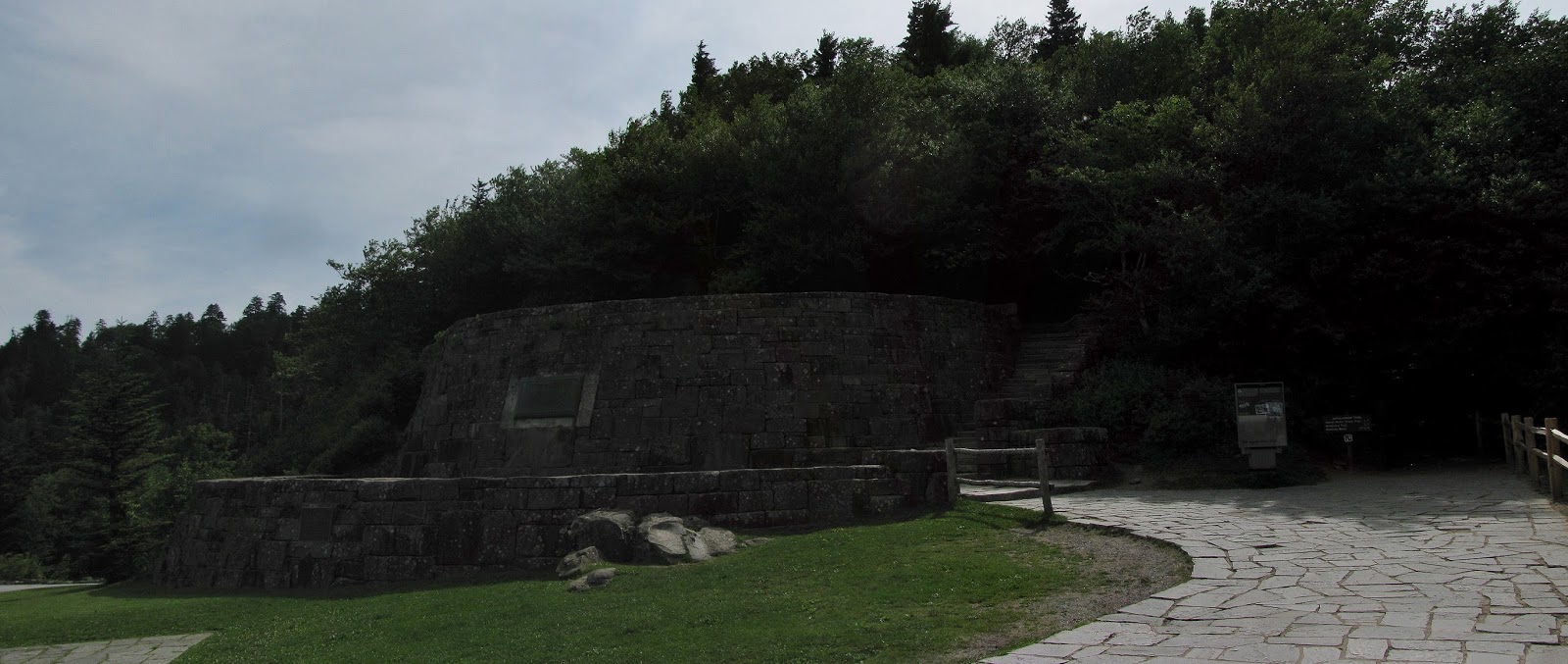
Anyone who
has been to the Smokies knows that Newfound Gap is like the gateway of the
Smokies. You pass through here on the way to either Gatlinburg or Cherokee and
it is also a stopping point if you are headed up to Clingmans Dome from the
Tennessee side. It also has historical significance as it was here that
President Franklin D. Roosevelt dedicated the park in 1940. You can even walk up
and stand where he gave his speech 75 years ago. On the stone viewing deck one
will find a large plaque for the Laura Spelman Rockefeller Memorial, named in her honor by, husband, John D. Rockefeller
Jr., who donated more than $5 million for land acquisition for the park in Laura's honor.
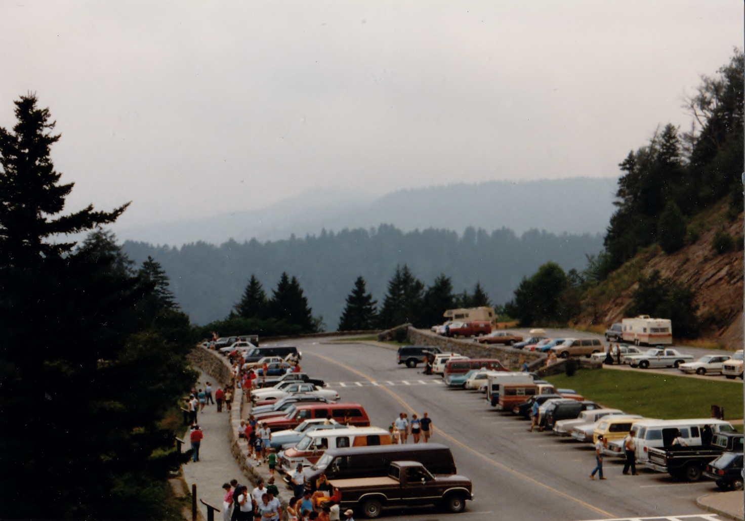
Newfound Gap is also the home of the plaque that designates the park as World Heritage site. There are also a number of
wonderful vistas and a sign in the parking lot that is the state line between
North Carolina and Tennessee. Oh, there are also bathrooms and plenty of
parking. For these reasons this is a popular spot for tourists. I have done the
touristy stuff here plenty of times.
One of the information signs in 2014...
The famous Laura Spelman Rockefeller Memorial...
...overlook...
...& plaque.
With U.S. Geological Marker in 2013...
...up close on my latest visit...
...this had been added since I was last here in 2014.
Newfound Gap in 1986...
...& 2015, almost 30 years later.
View of....
...Mount LeConte...
...Clingmans Dome.
World Heritage Site plaque.
With the current state-line sign...
...30 years ago it was different with a Tennessee side...
...& North Carolina side.
The restrooms.
Oh, I
almost forgot the Appalachian Trail (AT) cuts right through the parking lot of
the gap. Because of these it is the trailhead from my hike today out to the Jumpoff
and the Charlie's Bunion. I took a little time to enjoy the sights of Newfound
Gap, but my day lied ahead on the AT. It is funny, when at the Gap there are
people everywhere, but once you head a couple hundred yards up the trail people
just seem to vanish, which I had to say was nice.
The AT before it reaches Newfound Gap headed north.
Headed north on the AT.
AT information sign.
2.7 miles before I head to the Jumpoff.
One of the
first things I noticed was the temperature. While it was noticeable cooler at
Newfound Gap than Sugarlands when I got on the trail it was really cool and
felt sooo good. A course coming out of a gap the AT headed up. It wasn't too
steep and there were also a couple of vista within the first mile. You also
pass through Spruce and Fir forest and which also means the damage caused by the Balsam Woody Adelgid.
Two white blazes as I head up from Newfound Gap.
Mountain Wood Sorrel.
Low bridge.
Besides beautiful trails...
...there were some nice vistas on the way.
Victim of an adelgid.
It is also about this time that the AT mostly travels across a
ridgeline. It will do this a lot all the way to the Charlie's Bunion. At 1.7
miles the AT comes to its first junction with Sweat Heifer Trail which leads 2.1 miles to the Sweat Heifer Cascade and 3.7 miles to the Kephart Shelter.
At the junction with the Sweat Heifer Trail.
The next
junction is another mile down the trail where the Boulevard Trail meets the AT
and it is also my detour to the Jumpoff. When I read about this hike in the Day Hikes of the Smokies it had the hike to the Jumpoff together with the Charlie's
Bunion, but as the book says they could be done separately. Anyway, what is another mile-and-a-half?
Also the Boulevard Trail leads 5.3 miles to Mount LeConte. Because of that
there was a lot of traffic headed that way, the reason? The most popular trail
to LeConte and the lodge is the Alum Caves Trail, which because of trail
maintenance is closed Monday thru Thursday.
Another vista.
Looks like a trail tunnel.
At the junction with the Boulevard Trail.
It wasn't
long (between 0.2 and 0.3 miles) before the trail forks again. The Boulevard
heads left toward LeConte and the trail right, the one I need, headed up Mount Kephart and the Jumpoff. It is here that I need to say that if you read some of
the literature on the Jumpoff and the trail too it is steep and rugged (especially
from a GSMNP trail) is spot on. The first part of the trail is pretty tough
going and doesn't level off until you reach the summit of Mount Kephart. There
are some nice views here of Mount LeConte, but your journey is just half done.
The junction for the trail too...
...the Jumpoff.
The Jumpoff trail up Mt. Kephart is quite roughed.
Vista from summit of Mt. Kephart...
...with a great view of Mt. LeConte.
The trail now heads down and is steep and rough in spots. You know your almost
there when the ridgeline trail cuts through Catawba Rhododendrons and then you
come up to the somewhat narrow, but not dangerous, cliff face of the Jumpoff.
I have arrived at the Jumpoff...
...what a vista!
At the Jumpoff.
Another look from the edge of the outcrop.
There also were some Catawba Rhododendrons.
The Cup made an apperance!
My next stop...Charlie's Bunion.
Let me just
say...wow what a view! This north to northeast facing vista with views of
some of the Smokies biggest mountains, Mount Chapman and Tennessee second
tallest Mount Guyot. I will say that it is one of the best vistas I have seen
not just in the Smokies or the AT, but anywhere. Another cool thing was over
from the Jumpoff I could hear nest of what sounded like hawks. Oh, and one more
thing you can see my next destination, the narrow, rocky razorback outcrop of
the Charlie's Bunion. I could even see people though my monocular. This detour
to the Jumpoff was well worth the extra miles.
Headed back over the summit of Mt. Kephart...
...LeConte had some clouds on the way back.
Headed back north on the AT.
After a
while it was back on the trail and back up and over Mount Kephart to the Boulevard
Trail, then reconnecting with the AT and heading north, 1.3 miles to the
Bunion. Just under a half-mile down the trail is a sign pointing the way to the
Icewater Spring Shelter. I had forgotten about this shelter it is a typical
Smokies one that sleeps 12. Here you will find bear cables and a privy. About this
privy it was possible the second nastiest privy I have used (first goes to
Blood Mountain back in March). Down from the shelter on the AT is also a piped
water source, which was pretty much the only one I had seen all day. At least I
knew I could get water if needed on the way back.
Quick stop...
...at Icewater Spring Shelter...
...look inside.
Headed back north...
...where you cross the piped spring.
Back on ridgeline.
The trail
heads down as the Charlie's Bunion is about 500 feet lower than Mount Kephart.
The decent is typical of a ridgeline, it doesn't seem that bad going, but
coming back it seems a lot steeper, I call this stealth incline. The first half
is rocky and travels through some old growth Spruce Fir forest, it was nice.
The AT then comes to a clearing which made for a lovely picture. The next
ridgeline clearing provided a wonderful view of Mount LeConte and you can also
see the finish line that is the Charlie's Bunion.
The AT opens up as it heads towards...
...Charlie's Bunion.
Cool tree.
One more uphill through some forest before...
...coming to another vista.
It not long before you come
to the final open ridgeline and can see the sign that lets you know you have
arrived. Passing the sign it is just a short distance down to the razorback
outcrop. When you get there you know why the sign said closely control children.
The AT heads down to...
...the junction to the trail out too...
...Charlie's Bunion (remember to control your children).
To get to
the main outcrops you have to climb up from the trail. There is two, small separate
rocks. The furthest one does look a bit sketchy until you get out to it and it
is not too bad. I will say not everyone would ventured out to here, but let me
say it was worth it. As great of a view that the Jumpoff offered, the Bunion is
even better. I mean it is the best natural vista in the Smokies that I have
visited. You can see back up toward the Jumpoff on Mount Kephart. Also to the
west is a great view of Mount LeConte and visible to the northeast again are
Mount Guyot and Chapman. This vista is just awesome, it was even better than advertised!
After sitting on the further out rock I moved back to the second one and
enjoyed my lunch of an EPIC Lamb, Current and Mint bar...nice!
The vista from the Bunion...
...& from the lower outcrop (seen above left).
The lower outcrop of Charlie's Bunion...
...Wood Booger from here....
...& the Cup...
...& Pete.
Now let me
say you don't need to climb out on the razorback outcrop to enjoy the view. The
trail on both sides of the outcrop awards great looks at this vista. Behind the
razorback outcrop is a large cliff when I looked up from the outcrop I
spotted people up above me. So, I decided to try and head up there. I found a
path on the rock face and climbed up and once again another incredible view.
Someone up there told me that there is a trail that leads up from the AT to
here, so when I left, to head back, I went this direction and it led back to the
trail. It was a shame I had to leave the Bunion, but it was time to head back.
This was an incredible view, plus there were...
...Catawba Rhododendrons.
Looking down on the trail from the high outcrop...
...looking northwest...
...from here you can also look east.
the trail that leads up to the high outcrop...
...leads back to the AT.
Headed back sout on the AT.
I knew it
was uphill heading up Mount Kephart which is what I expected, but it seemed
like I went uphill most of the way going up from Newfound Gap , but going back it seemed like less downhill than it should have been. However, I did make good time as the hike to and at the Charlie's
Bunion took about four hours while the hike out just took around two, not bad
for four miles on a ridgeline. About a mile before I got back I started to hear
vehicles, mostly motorcycles, but I knew I was back when I heard and then
spotted the tourist at Newfound Gap. After being with hikers all day it was
almost culture shock to be again among tourist.
It was uphill from the Bunion.
Back to the shelter junction.
The AT near the Boulevard Trail junction was this...
...cool tree stump.
On the way back...
there was plenty...
...of trail beauty...
...& vistas.
Rocky spot before...
...trail desends to Newfound Gap.
After
enjoying the area around the gap it was time to head back down toward
Gatlinburg. On the way down I did stop at one of my favorite overlooks the
Carlos C. Campbell. It offers a great view of the other side of Mount LeConte.
Then, further down I spotted some flowers off the road and stopped and headed down
the Sugarlands Trail and these wildflowers were what I though, blooming Rosebay
Rhododendrons.
Vista from Newfound Gap in 1980's...
...& today.
Well, 15 miles down, but first as stop...
...at the Carlos C. Campbell Overlook & it view of Mt. LeConte...
...on some days it is not great (like in 1986)...
...but others wonderful (like in 2013).
On the Sugarlands Trail were some of the first Rosebay Rhododendrons.
While I
stopped here earlier I made another stop at the Sugarlands Visitor Center.
While I am going to do a more comprehensive blog on the visitor center, I
stopped today to get me a Charlie's Bunion patch and hiking stick medallion, I
thought I earned them. I also found the Black Bear that was once at the museum
in the visitor center.
I found were they moved the bear.
With the main sign on the Tennessee side.
Last stop at the NOC...
...& the big bear...
...& the conditions for my hike.
My last stop was at the Nantahala Outdoor Center in
Gatlinburg. I didn't get to go here back in December, so I was stopping today.
Overall, I will say I needed this hike, after all of the things that had happened
this day on the trail was just what the doctor ordered.
GSMNP Hike: Newfound Gap To The Jumpoff & Charlie's Bunion
My Take:
For Difficulty – AT: 3 Stars & The Jumpoff Trail: 4 Stars
For Trail Conditions – AT: 4 Stars & The Jumpoff Trail: 2 Stars
For Views – 5 Stars
For Solitude – 3 Stars
Overall – I have to say this was not just one of my favorite Smokies hikes, but one of any kind. While the ridge-line hike of the AT was three stars I up the difficulity to four because for the Jumpoff Trail, which is pretty roughed. The AT & Boulevard Trails are in excellent shape, but like I said above the Jumpoff could use some work. I have to say that the Jumpoff & Charlie's Bunion have some of the most breathtaking views in the Smokies. While the trailhead at Newfound Gap is full of tourist the crowds melt away down the trail and it wasn't too crowded at either spot.
Pete’s Take :
For Difficulty – 3Rabbits Paws
For Trail Conditions – 4 Rabbits Paws
For Views – 5 Rabbits Paws
For Solitude – 2Rabbits
Paws
Overall –
I have to say that this was a great hike. For one the Lummox didn't complain much on the day and two what is better than being on the AT...being on the AT in the Smokies! The AT is great and I didn't find the Jumpoff to be that bad either. The Lummox is right the views from the Jumpoff & Charlie's Bunion are spectacular! While there were people at both spots they were hikers, we left all the people I don't like (kids) at Newfound Gap. It was a great hike.


No comments:
Post a Comment