
Since I got back into hiking there is a number of Appalachian Trail (AT) hikes I have wanted to do and one of these was to Mount Rogers from Elk Garden. Well, on Friday I finally made my way to this iconic spot. Besides being one of the AT's most beautiful spots this hike also checked off another state's highest peak as Mount Rogers is Virginia's. However, this hike across the Virginia Highlands is more than just going to Mount Rogers. It offers sweeping vistas and some great forest trails that make this one of the more popular outings on the AT in Virginia. Also, I want to try to make it to as many of the highest peaks in each state and Mount Rogers would be my fourth (the others are pictured below).
 |
| Georgia Highest Peak: Brasstown Bald (4,784 ft) |
 |
| North Carolina Highest Peak: Mount Mitchell (6,684 ft) |
 |
| Tennessee Highest Peak: Clingmans Dome (6,643 ft) |
One of the reasons I had yet to make it here is the drive. From St. Clair it is a two-hour-plus trip, which meant that when I lived in Georgia I would have to do it when visiting and I never got the chance. After I moved back to East Tennessee I simply had not done any hiking up that way and that made it seem longer (Cravers Gap is also about two hours, but it just seems closer). But last year I finally did some AT hiking in Virginia. First during Damascus Trail Fest back in May and then on a Sierra Club Backpack in July on the Virginia Highlands, out of Grayson Highlands State Park, on the AT. I almost went on the annual New Year's Hike of the Mid-Appalachian Highlands Club to Mount Rogers, but I instead went to Cades Cove. Then a couple of weeks ago I almost went but opted for the hike out of Horse Creek to Buzzard Roost. Because of the drive I decided to wait until after the Daylight Savings Time change, but then we had the week of winter weather, and then other things got in the way. Finally, the stars seemed to align and I decided to make the long trip up Interstate-81 to the trailhead at Elk Garden.
Before reaching Elk Garden I made a quick stop at the Skulls Gap Overlook on VA-600. I will say that the road to the trailhead is actually really good, it reminded me of TN-143 to Carvers Gap. Another way it reminded me of Carvers Gap is the beautiful setting between mountains and the feeling of being on top of the world. Other similarities are the large parking area and a vault toilet.
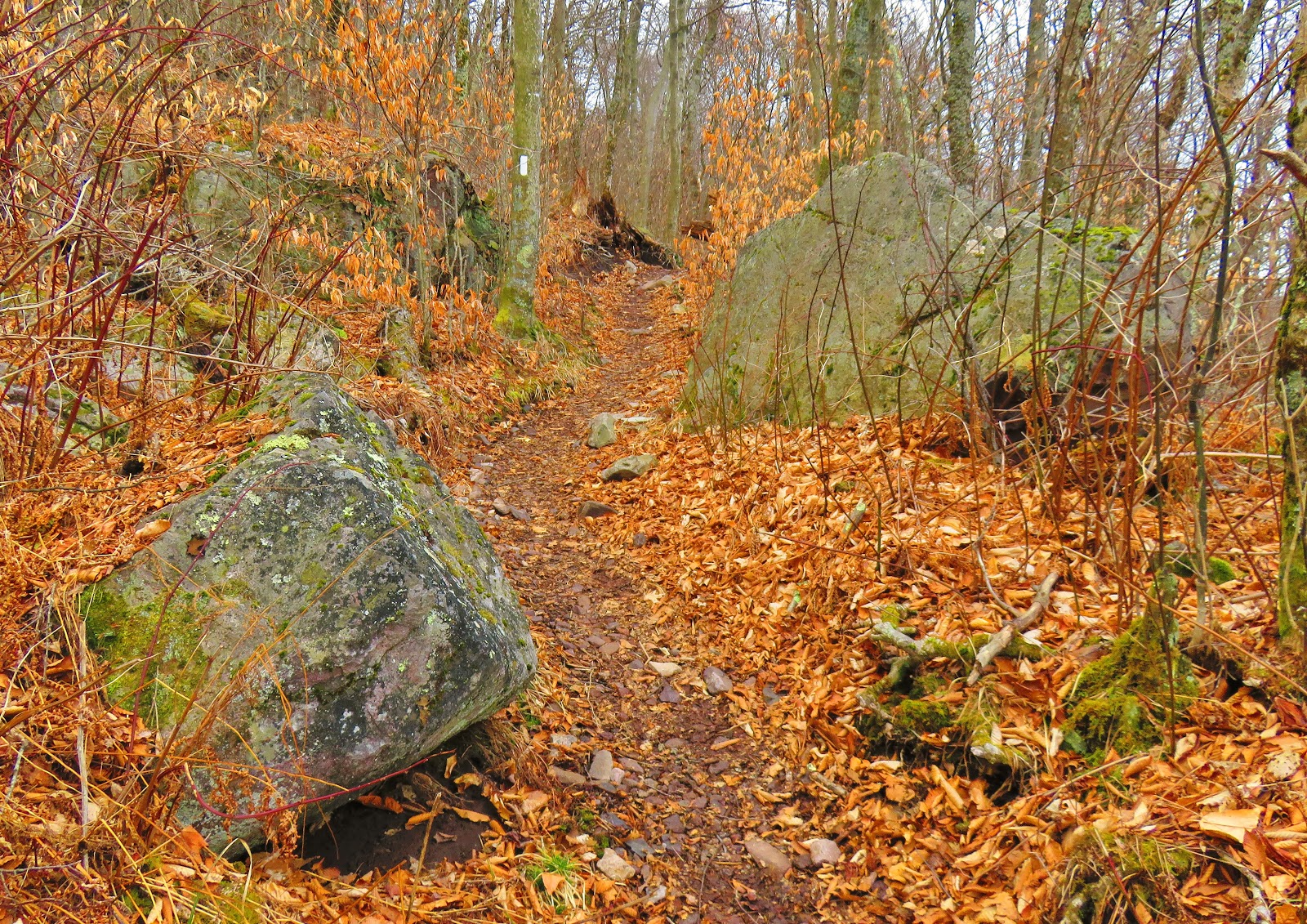
As for the hike to head towards Mount Rogers you go north on the AT, cross the road and through the gate (because and horses graze here, but more on that later). Then there is a junction with the Virginia Highlands Horse Trail with goes right and the AT follows the white blazes up, Elk Garden Ridge. Once it flattens out there are some wonderful views. Besides outcrops, to the left is a bench named in honor of Chuck Hudson.
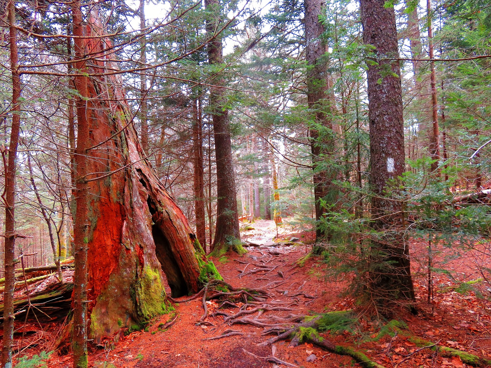
It is not long before the trail enters the woods and the Lewis Fork Wilderness. After passing through a stile there is a trail register box. I forgot to sign the one at Elk Garden, but I signed this one. You will notice the trees here are almost all hardwoods, but as one goes up that will change.
At 1.8 miles there is a junction with blue blazed side trail, to the right, leading to a camp site. The reason is in one-tenth-of-a-mile you reach Deep Gap with another side trail leading to the Virginia Highlands Horse Trail, but no camping. Just up the trail, the AT takes a hard right as the Mount Rogers Trail comes in from the left ( which leads to Grindstone Campground).
This spot for the next mile was the most challenging as it was the steepest and rocky in spots. Through here were a number of streams, springs and some leftover spots of ice. At three miles the trail passes and open fence which leads out onto Brier Ridge saddle, but more on that later.
You will notice by this point you have left most of the hardwoods behind and is now mostly evergreens. Except for a few trees here and there the AT now has a number of views. Also in this area, I ran into the famous "wild ponies" of the Virginia Highlands. I got to see some back in July, but on this day I encountered maybe the most famous pony named Fabio (see photo).
After making friends with the Fabio I came to the trail junction that leads to the Mount Rogers Summit, but I decided to do it later and head just down the trail to Thomas Knob Shelter. This shelter, built in 1991 sleeps 10, but if you are days hiking to Mount Rogers I would definitely make the short trip to here as the rocks behind the shelter has incredible views! Oh, and it does make a great place to have lunch...which I did.
While there I spotted a small knob farther north on the AT and I decided to head out to it. This might be Thomas Knob, but whether it is called that it also had nice views, including one of Mount Rogers, where I was heading next.
The trail to the summit of Virginia's Highest Peak is half-a-mile and is not too difficult. It almost feels like a different world when the trail enters cover of red spruce and Fraser fir. The Fraser's are the only fir tree native to the south (with this being the north most point of its range) and red spruce is native to the New England and Canada. You could almost imagine all sorts of mythical creatures roaming here. The trail finally curves up past a big Rock and before you know it you are at the "Top of Virginia." Even though the spur trail isn't too hard Mount Rogers is the most difficult state high peak to reach in the south.
On the hike back the biggest highlight was a ramble across the Brier Ridge saddle. You know you are there because of the old fence step, but today it isn't needed as the fence is gone. The blue blazed trail passes two huge rocks and ends up at an old trail junction sign. Let me say the hike across it was well worth it with some spectacular views including Whitetop Mountain and the parking area at Elk Garden. I then took a trail up to the fence line and then back in the woods to the AT.
The rest of the way back was woods and then the hike back up and over Elk Garden Ridge to the parking area. The hike was over 10 miles of some of the most beautiful terrain in Virginia and a truly memorable day.

 |
| At Damascus Trail Fest in May... |
 |
| ...Virginia Highlands in July. |
 |
| Buzzard Roost earlier this month. |
 |
| Entering the Mt. Rogers Recreation Area... |
 |
| Skulls Gap Overlook... |
 |
| ...& vista. |
 |
| Where I am heading... |
 |
| ...up VA-600... |
 |
| ...to Elk Garden. |
 |
| View of the parking area... |
 |
| ...the vault toilet... |
 |
| ...view from the parking area. |
As for the hike to head towards Mount Rogers you go north on the AT, cross the road and through the gate (because and horses graze here, but more on that later). Then there is a junction with the Virginia Highlands Horse Trail with goes right and the AT follows the white blazes up, Elk Garden Ridge. Once it flattens out there are some wonderful views. Besides outcrops, to the left is a bench named in honor of Chuck Hudson.
 |
| The hike starts crossing the road & going through the gate... |
 |
| Heading left... |
 |
| ...remember no horses... |
 |
| Four & half miles... |
 |
| ...following the white blaze. |
 |
| Chuck Hudson Bench... |
 |
| ...& view. |
It is not long before the trail enters the woods and the Lewis Fork Wilderness. After passing through a stile there is a trail register box. I forgot to sign the one at Elk Garden, but I signed this one. You will notice the trees here are almost all hardwoods, but as one goes up that will change.
 |
| Heading into the woods... |
 |
| ...through the stile... |
 |
| ...trail registration box... |
 |
| ...heading into Lewis Fork Wilderness.... |
 |
| ...through hardwood forest. |
At 1.8 miles there is a junction with blue blazed side trail, to the right, leading to a camp site. The reason is in one-tenth-of-a-mile you reach Deep Gap with another side trail leading to the Virginia Highlands Horse Trail, but no camping. Just up the trail, the AT takes a hard right as the Mount Rogers Trail comes in from the left ( which leads to Grindstone Campground).
 |
| Blue blaze to camping site goes right... |
 |
| ...Deep Gap junction... |
 |
| ...Mt Rogers Trail comes from the left... |
 |
| ...AT goes right. |
This spot for the next mile was the most challenging as it was the steepest and rocky in spots. Through here were a number of streams, springs and some leftover spots of ice. At three miles the trail passes and open fence which leads out onto Brier Ridge saddle, but more on that later.
 |
| The AT goes uphill... |
 |
| ...gets rocky... |
 |
| ...there are streams, springs... |
 |
| ...& there was still ice on the trail... |
 |
| ...quick look at the Brier Ridge saddle. |
You will notice by this point you have left most of the hardwoods behind and is now mostly evergreens. Except for a few trees here and there the AT now has a number of views. Also in this area, I ran into the famous "wild ponies" of the Virginia Highlands. I got to see some back in July, but on this day I encountered maybe the most famous pony named Fabio (see photo).
 |
| Out of the forest... |
 |
| ...with views. |
 |
| The most famous pony Fabio! |
 |
| Here are more ponies. |
After making friends with the Fabio I came to the trail junction that leads to the Mount Rogers Summit, but I decided to do it later and head just down the trail to Thomas Knob Shelter. This shelter, built in 1991 sleeps 10, but if you are days hiking to Mount Rogers I would definitely make the short trip to here as the rocks behind the shelter has incredible views! Oh, and it does make a great place to have lunch...which I did.
 |
| The trail junction for Mt. Rogers... |
 |
| ...put I decided to first head out to... |
 |
| ...Thoms Knob Shelter... |
 |
| ...inside... |
 |
| ...shelter plaque... |
 |
| ...my lunch spot behind the shelter. |
While there I spotted a small knob farther north on the AT and I decided to head out to it. This might be Thomas Knob, but whether it is called that it also had nice views, including one of Mount Rogers, where I was heading next.
 |
| ...Heading out to "Thomas Knob" I first go through a stile... |
 |
| ...that is the knob where the trees are... |
 |
| ...& view... |
 |
| ...where Pete & I head next, Mt. Rogers. |
The trail to the summit of Virginia's Highest Peak is half-a-mile and is not too difficult. It almost feels like a different world when the trail enters cover of red spruce and Fraser fir. The Fraser's are the only fir tree native to the south (with this being the north most point of its range) and red spruce is native to the New England and Canada. You could almost imagine all sorts of mythical creatures roaming here. The trail finally curves up past a big Rock and before you know it you are at the "Top of Virginia." Even though the spur trail isn't too hard Mount Rogers is the most difficult state high peak to reach in the south.
 |
| Headed to the summit of Mt. Rogers... |
 |
| ...is blue blazed... |
 |
| ...soon you enter the evergreen forest... |
 |
| ...it is a beautiful hike... |
 |
| ...once you pass this rock you arrive at... |
 |
| ...Mt, Rogers Summit... |
 |
| ...Wood Booger & summit marker. |
On the hike back the biggest highlight was a ramble across the Brier Ridge saddle. You know you are there because of the old fence step, but today it isn't needed as the fence is gone. The blue blazed trail passes two huge rocks and ends up at an old trail junction sign. Let me say the hike across it was well worth it with some spectacular views including Whitetop Mountain and the parking area at Elk Garden. I then took a trail up to the fence line and then back in the woods to the AT.
 |
| Headed back... |
 |
| ...toward Elk Garden... |
 |
| ...more trail beauty... |
 |
| Back in the forest. |
 |
| The old fence stairs are no longer needed... |
 |
| ...the big rocks on the Brier Ridge saddle... |
 |
| ...old signpost at the junction... |
 |
| ...which has this view... |
 |
| ...Whitetop Mountain & Elk Garden. |
 |
| Passed this sign on the way back to the AT. |
The rest of the way back was woods and then the hike back up and over Elk Garden Ridge to the parking area. The hike was over 10 miles of some of the most beautiful terrain in Virginia and a truly memorable day.
 |
| AT hugs some rocks. |
 |
| Two miles to go... |
 |
| ...late in the day, I passed thru & section hikers. |
 |
| Back to the stiles... |
 |
| ...out of the woods... |
 |
| ...up Elk Garden Ridge... |
 |
| ...& back to the parking area. |

Great photos of a great hiking route, ponies, open meadows, forest, it's got everything.
ReplyDeleteThis tent with stove collection gives campers the ability to enjoy luxurious warmth while still experiencing true outdoor living in the wild tent with stove
ReplyDelete