
Remember last week when I didn't hike from Newfound Gap to
Charlies Bunion…well I am back! For the last hike of the winter season I
decided to hike the High Country of the Great Smoky Mountains National Park
(GSMNP) on the Appalachian Trail (AT). Saturday
when I was in Greeneville there was snow on Camp Creek Bald, so I expected
maybe to see some snow. When I got to Sugarlands Visitor Center there was no
snow, but turkeys.


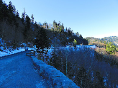
Anyway, as I made my way up the Newfound Gap Road I started to see snow and the higher I went the more I spotted. I will say there wasn’t as much as last week because the wall at the Morton Overlook wasn’t a pile of snow. When I arrived at Newfound Gap there wasn’t too much snow and ice (expect for the piles that had been plowed).


So, I got my gear together and set out, but it wasn’t long (I was barely up the trail) that I discovered that it was icy, really icy. However, I had a secret weapon a set of crampons that Dad and Terry got me two Christmas ago…YakTrax. Now I am going to do a special blog on these, but let me just say here that this would have been a much harder and more dangerous hike without these. If you are going to hike on icy trails, get a pair! I hiked this last summer, but I think the trail was even more beautiful wearing its winter coat…it was stunning in sections. But, because of the snow and icy I didn’t make as good time as I did back in June.


I will say there are not many trails in the Smokies that are as picturesque as this one. After passing the junction with the Sweet Heifer Creek Trail and Boulevard Trails I finally reached the Ice Water Spring Shelter (never more apt than today) this marks the point where it is a mile to the Bunion and it almost all downhill (which with the ice was harder). This part of the trail was icy and sloppy at the same time.


I finally reached the Bunion and there are not many vistas better in the GSMNP. After enjoying the view and sharing the main rock with a couple of college girls I headed off down the trail around Fodderstack (the old name for the whole rock formation). The whole way was a vista with the added bonus of beautiful icicles. Once I finally ran back into the AT and I headed back south on the trail. First I found the trail up to the top of Fodderstack (which I came down in summer). From here you get the same vista, including Mount Kephart and Mount LeConte, but you can look down on the Bunion.


That mile that was downhill was now up and it was slicker and sloppier on the way back. Except for this spot it wasn’t too tough heading to Newfound Gap. I did decide not to head out to the Jumpoff (I will do it again when I do the Boulevard Trail to LeConte) because it was getting late and I was tired.


Now I must mention some of the people I passed on my last mile of the trip. First there was a family with not much gear and a kid. The look like they had taken a wrong turn at Newfound Gap. However, it got worse I passed a group of college kids and some were in shorts and tennis shoes. They looked like a rescues waiting to happen. It was four o’clock and when one of the girls asked if it got better (as she slipped on the ice) I said no. Then they asked if it was a mile to the Bunion and informed them more like three (plus four coming back). It was in the low 40's and the winds had picked up considerably, I just hope they got out alive.


When I finally arrived back at Newfound Gap I decided to look for this spot called the lost Hiker Tunnel. I have driven over where it is located a number of times, but never knew it was there. Then I read a Facebook post about it and decide I wanted to take a look. So, I parked at the entrance to Clingmans Dome Road (it is closed in the winter) and hiked the road about two tenths of a mile, past pull-off to what looks like a bridge to where the Hikers Tunnel is at. It wasn’t too hard to find as other people were already there. It is a small tunnel under the road built by the Civilian Conservation Corp. Some believed the AT use to pass through it, but the going theory is the Thomas Divide Trail use to pass through here, but was cut off when the new Newfound Gap Road was built separating it from the rest of the trail. Whatever it origin it is pretty cool.


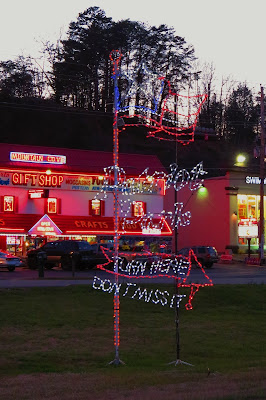
After that I hit a number of overlooks and headed home. I even got to see some of the remaining lights of the Smokies Winterfest as it ended Sunday.


Anyway, as I made my way up the Newfound Gap Road I started to see snow and the higher I went the more I spotted. I will say there wasn’t as much as last week because the wall at the Morton Overlook wasn’t a pile of snow. When I arrived at Newfound Gap there wasn’t too much snow and ice (expect for the piles that had been plowed).


So, I got my gear together and set out, but it wasn’t long (I was barely up the trail) that I discovered that it was icy, really icy. However, I had a secret weapon a set of crampons that Dad and Terry got me two Christmas ago…YakTrax. Now I am going to do a special blog on these, but let me just say here that this would have been a much harder and more dangerous hike without these. If you are going to hike on icy trails, get a pair! I hiked this last summer, but I think the trail was even more beautiful wearing its winter coat…it was stunning in sections. But, because of the snow and icy I didn’t make as good time as I did back in June.


I will say there are not many trails in the Smokies that are as picturesque as this one. After passing the junction with the Sweet Heifer Creek Trail and Boulevard Trails I finally reached the Ice Water Spring Shelter (never more apt than today) this marks the point where it is a mile to the Bunion and it almost all downhill (which with the ice was harder). This part of the trail was icy and sloppy at the same time.


I finally reached the Bunion and there are not many vistas better in the GSMNP. After enjoying the view and sharing the main rock with a couple of college girls I headed off down the trail around Fodderstack (the old name for the whole rock formation). The whole way was a vista with the added bonus of beautiful icicles. Once I finally ran back into the AT and I headed back south on the trail. First I found the trail up to the top of Fodderstack (which I came down in summer). From here you get the same vista, including Mount Kephart and Mount LeConte, but you can look down on the Bunion.


That mile that was downhill was now up and it was slicker and sloppier on the way back. Except for this spot it wasn’t too tough heading to Newfound Gap. I did decide not to head out to the Jumpoff (I will do it again when I do the Boulevard Trail to LeConte) because it was getting late and I was tired.


Now I must mention some of the people I passed on my last mile of the trip. First there was a family with not much gear and a kid. The look like they had taken a wrong turn at Newfound Gap. However, it got worse I passed a group of college kids and some were in shorts and tennis shoes. They looked like a rescues waiting to happen. It was four o’clock and when one of the girls asked if it got better (as she slipped on the ice) I said no. Then they asked if it was a mile to the Bunion and informed them more like three (plus four coming back). It was in the low 40's and the winds had picked up considerably, I just hope they got out alive.


When I finally arrived back at Newfound Gap I decided to look for this spot called the lost Hiker Tunnel. I have driven over where it is located a number of times, but never knew it was there. Then I read a Facebook post about it and decide I wanted to take a look. So, I parked at the entrance to Clingmans Dome Road (it is closed in the winter) and hiked the road about two tenths of a mile, past pull-off to what looks like a bridge to where the Hikers Tunnel is at. It wasn’t too hard to find as other people were already there. It is a small tunnel under the road built by the Civilian Conservation Corp. Some believed the AT use to pass through it, but the going theory is the Thomas Divide Trail use to pass through here, but was cut off when the new Newfound Gap Road was built separating it from the rest of the trail. Whatever it origin it is pretty cool.


After that I hit a number of overlooks and headed home. I even got to see some of the remaining lights of the Smokies Winterfest as it ended Sunday.


No comments:
Post a Comment